
Facebook Twitter Flickr YouTube RSS Feed

Written on: July 17th, 2012 in Archaeology Updates, US301
Fieldwork concluded this week on the Elkins site, with work focusing on bisecting the suspected post holes across the site and finishing the larger prominent features. As could be expected, some of the suspected postholes indeed turned out to be historic posts, while others are now interpreted as “non-cultural” disturbances caused by tree roots or animal burrows. Having sorted out which is which, we can now start to connect the dots, and, we hope, to the discern the configuration of fences that probably delineated garden and yard areas. Dismantling the stone side walls of the root-cellar revealed that crushed red brick mixed with loam was placed between the large cobbles during construction, evidently to prevent the otherwise dry-laid stones from slipping out of position. An entrance became apparent in the southwest corner of the root-cellar with a step at the base, implying that there was an entrance into the cellar from outside the house. The large circular feature has now been fully excavated, and although it remains puzzling, we now have additional data to help us work out what it is.

Circular Pit Feature
The rectangular excavation seen on the photo was cut by us through the center of the pit to examine the stratigraphy below the pit, and is not part of the original construction. The pit feature has an approximate diameter of 15 feet and extends three feet below the plowzone. The large post holes, positioned every three feet around the perimeter of the base of the pit, contain smaller posts ranging from four to six inches diameter and angled 10 degrees inward. Rocks originally thought to be positioned under each post are actually wedged under and over the posts to prevent them from shifting or falling inward. The slabs recovered from the upper center of the fill may be pieces of one larger broken slab. No other artifacts have been recovered from this enigmatic feature. So we are still wondering: what is it? We have had several visitors to the site with interesting ideas (see last week’s post), but none are as yet completely satisfactory. A competing possibility to a wolf trap/pit is a “field root pit” type of root cellar used to store staples such as potatoes, carrots and turnips. Field root pits are often rectangular but can be circular. Some also have peaked roofs. As always your thoughts, are helpful and welcome.
Written on: July 17th, 2012 in Archaeology Updates, US301
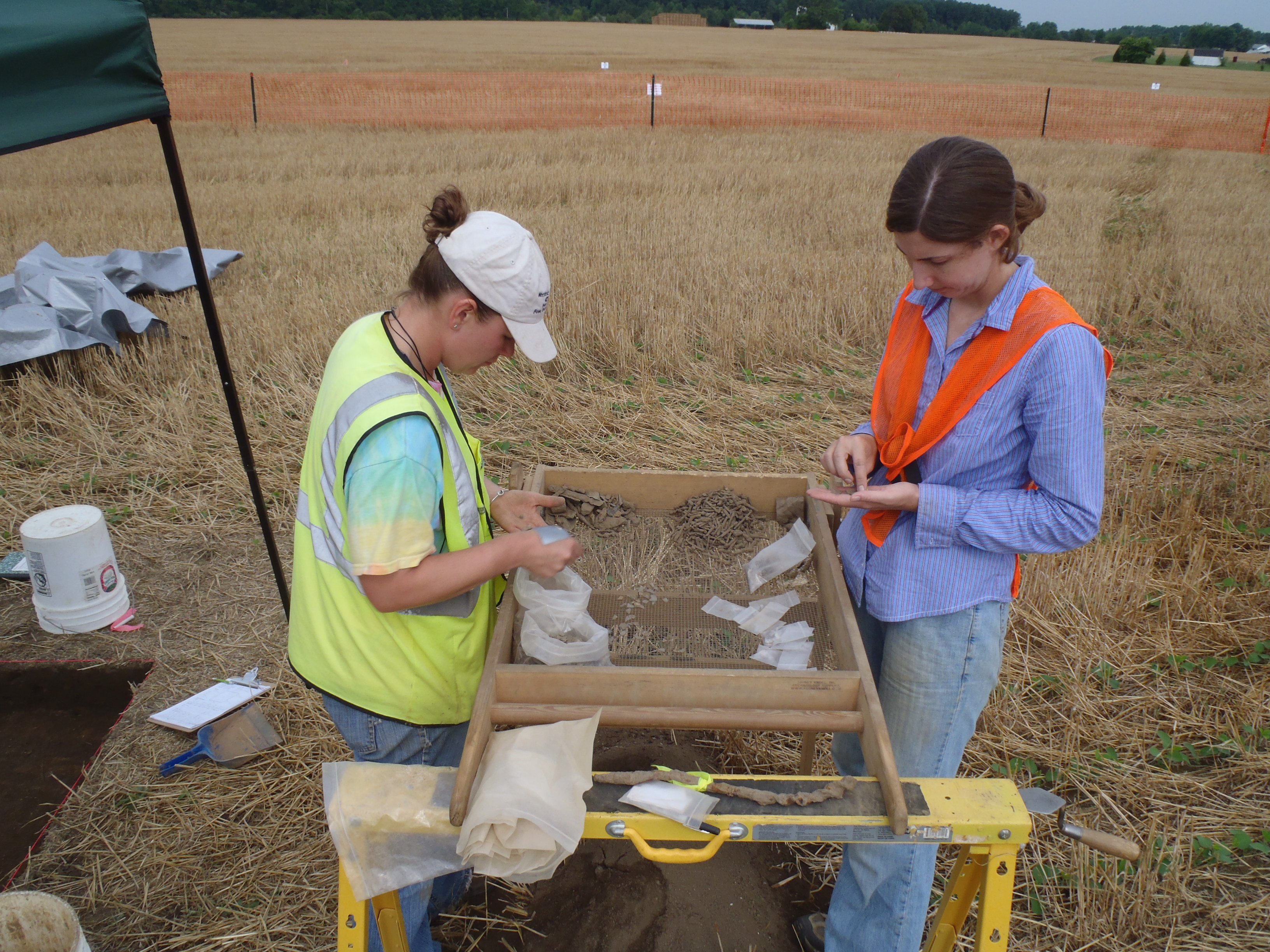
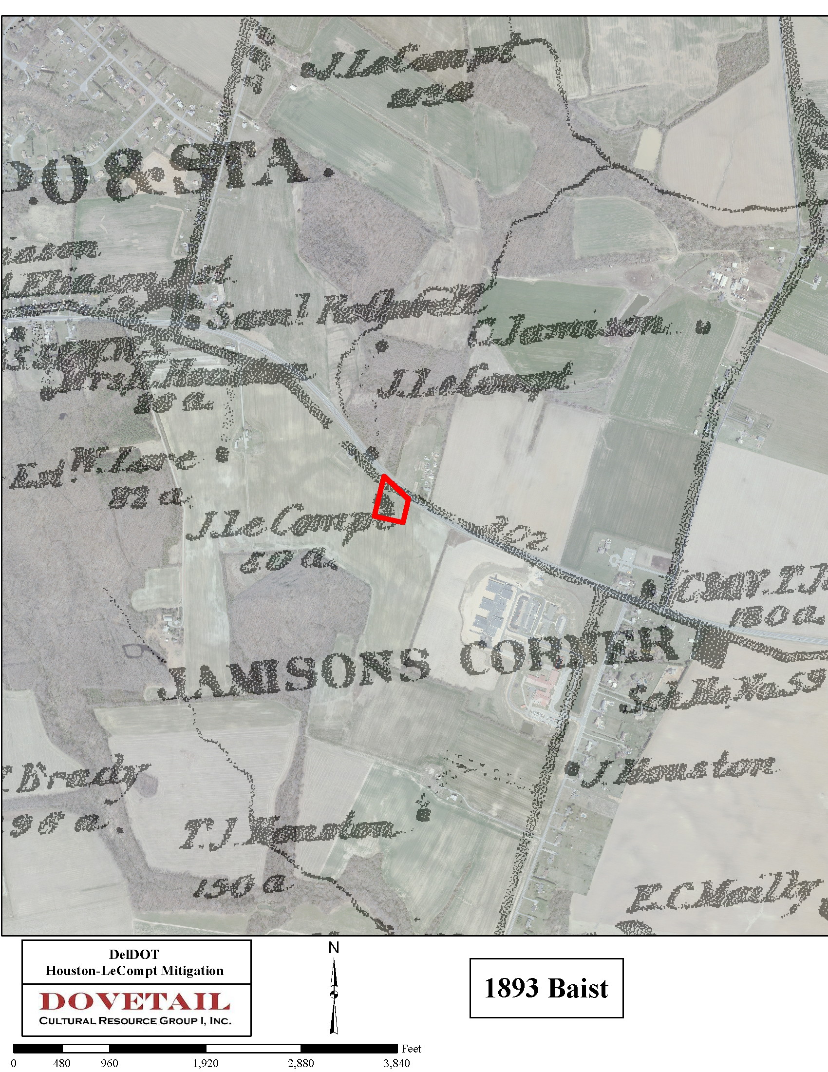
Excavation of the Houston-LeCompt site made great progress this week thanks to the crew’s hard work and much nicer weather since our last update. Our process of sampling the plowzone using ten 2×2 meter units is complete! We have sent over 6,500 artifacts to the lab to keep them busy washing, sorting, and analyzing already. Yikes! We are particularly excited to hear back from them about some specific items we found, including jewelry, ceramic doll parts, and several coins. We also started our next big task, which is removing the plowzone from the rest of the site using heavy equipment. Even at the bottom of our sample units we were finding features, and as the heavy equipment get closer to the foundation area located during the site evaluation, we expect to be finding a lot more. Along with the archaeology, we have also continued to do archival research and GIS mapping of the site. What we have found so far is already helping us to rethink the history of this site. It now appears that the circa 1770s Houston house may have been located west of our site, and we are uncovering the remains of a mid-19th century home instead. The house, built either by Richard Mulford or James LeCompt, was used as a tenant house in the late-19th century. We used GIS mapping and completed a study called “georeferencing”–tying historic maps to modern features and aerials through an overlaying process using specific geographic features as references)–to aid in this identification. Maps from 1849, 1868, and 1893 are helping us with site interpretation, and the marriage of these documents and archaeological finds is coming together very nicely thus far!
This coming week we are upgrading to even heavier equipment. A larger backhoe will help us remove the plowzone faster and get the crew back to what we all love doing as archaeologists, playing in the dirt! Our goal is to have the site completely cleared during our next eight-day work week, so that we can focus the rest of our time on investigating the subsurface features that are revealed. We are all looking forward to finding out what the root cellar fill has been holding for the last hundred or so years, just waiting for us to find it again.
Written on: July 17th, 2012 in Archaeology Updates, US301
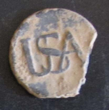
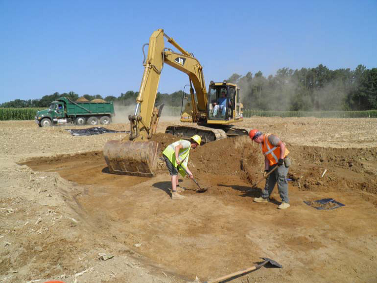 The first week of the Rumsey-Polk Tenant-Prehistoric site Phase III archaeological fieldwork excavation was off with a bang… and a clang – of the big mechanical excavator! To our surprise, traces of over 120 stains, pits, posts, and wells, otherwise known as “features,” have been found in the northern part of the site. Features like these can tell us a lot about the people who once called the site “home.” We expect to find many more exciting features as we move south to excavate near the former house in the coming weeks. The former residents of the site included prehistoric Native Americans, and later was occupied by tenants of the Rumsey, Polk, and Cochran families between 1740 and 1855. Along with using an excavator to remove about one acre of topsoil to search for features, our crew has also worked hard through the summer heat, sifting soil from several areas of the site to find artifacts that once belonged to the site’s occupants. Artifact of the week (below) is a pewter “USA” Continental Army button worn by a Revolutionary War soldier sometime between 1775 and 1783.
Delaware's Governor
State Agencies
Elected Officials
General Assembly
Delaware Courts
State Employees
Cities & Towns
Delaware State Code
State Regulations
Business First Steps
Phone Directory
Locations Directory
Public Meetings
Voting & Elections
Transparency
Delaware Marketplace
Tax Center
Personal Income Tax
Privacy Policy
Weather & Travel
Contact Us
Corporations
Franchise Tax
Gross Receipts Tax
Withholding Tax
Delaware Topics
Help Center
Mobile Apps
E-mail / Text Alerts
Social Media

Built by the Government Information Center
©MMXVIII Delaware.gov

