
Facebook Twitter Flickr YouTube RSS Feed

Written on: July 23rd, 2012 in Archaeology Updates, US301
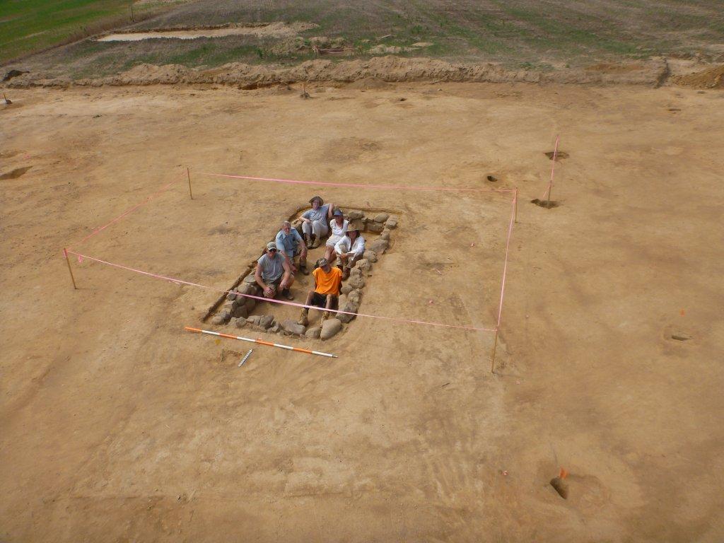
In the next few weeks we will record and map more than 525 features identified at the site — and then excavate several of the best ones to learn more about the lives of the people who lived at the site during the 18th and 19th century. One of the more interesting artifacts found last week was two fragments of a tortoise shell patterned teapot dating to the mid-18th century. Native American artifacts found this week included two spear or dart points, a 9,000 year old jasper Amos type and a 8,000 year old bifurcate, which remind us that Native Americans hunted and collected food at the site for thousands of years before Europeans arrived. Despite the heat, students and teachers from the Federal Highway Administration Summer Transportation Institute toured the site and joined us in a search for more artifacts. Volunteers from the Archaeological Society of Delaware also visited and toured the site.

Written on: July 23rd, 2012 in Archaeology Updates, US301
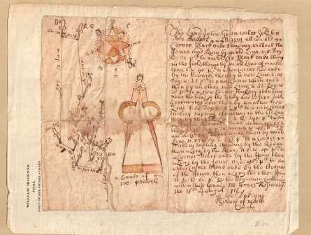
The last week of work on the Elkins Site saw a gathering of historic preservation specialists from the Delaware Division of Historic and Cultural Affairs, including State Historic Preservation Officer Timothy Slavin. This meeting enabled the team to share ideas with other specialists and to discuss interpretations and strategies for the site. Meanwhile, the Hunter Research historians have been following a trail of archival clues to help us identify past land uses and the people who occupied the Elkins site during the 18th century. Colonial land records have led us to the conclusion that what we now know as the Elkins farm property was divided into two farmsteads of approximately 100 acres each during the first four decades of the 18th century. The boundary between the two 100-acre tracts has proven somewhat elusive because the old boundary markers, mostly oak and hickory trees, are long gone. After some extensive analysis of the “metes and bounds” (the descriptions of the boundary lines in the deeds), we are now fairly confident that the area under current investigation is located on the northern 100-acre tract and that the boundary between the two tracts was just east of where we’ve been digging. A key piece of evidence is a remarkable deed drawn up by surveyor George Da Keyne in 1716. This deed recorded the conveyance of the southern tract from John Greenwater, a yeoman, to John Poullart (or Pullar), a weaver. Da Keyne embellished the deed with beautiful drawings of a compass and caliper, an unusual flourish. The drawings remind us of pen-and-ink styles common to Europe’s Late Gothic period. Da Keyne no doubt meant to convey his skill as a surveyor, but simple trigonometry proves that the metes and bounds do not come close to forming the closed polygon shown by the accompanying map. Errors such as these, which are common to colonial deeds, were no doubt introduced by topography and surveying technique; they simply reflect the state of the art at that time, not incompetence.
While we are not yet certain of the 18th-century occupants of the Elkins site, we now have two leading candidates: 1). the Greenwater family from circa 1707 to 1741; and, 2). the McCool/Merriss family from 1741 to 1793. John Greenwater, Sr. was a Welsh immigrant who arrived in the colonies in the late 1690s. He was involved with the establishment of the Welsh Tract Baptist Church in Newark in 1701. Greenwater appears to have settled on the northern tract between 1707 and 1716 accompanied by his wife Elizabeth Patterson Greenwater and son John Jr. , who inherited the property after his father’s death in 1722. John Greenwater Jr. continued to own the farm until 1741, when he sold it to John McCool, Sr., a planter, who had two years previously purchased the southern tract. John McCool, Sr., and his family are of considerable interest since their ownership coincides with the many mid-18th century ceramics and artifacts being found at the site. So far we’ve traced four generations of the McCool family to the property: 1). John McCool, Sr. and his wife Sarah; 2). John McCool, Jr. and his siblings Thomas, George and Elizabeth; 3). Mary McCool Merriss, the daughter of John McCool, Jr., and her husband John Merriss, a blacksmith; and 4). the Merriss children Benjamin, Richard, Sarah and two other girls as yet unidentified. We’re looking forward to compiling more demographic data on these families to help us to develop the site’s historic archaeological contexts.
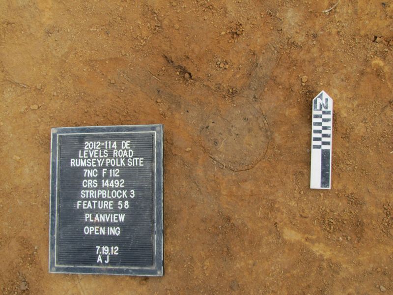
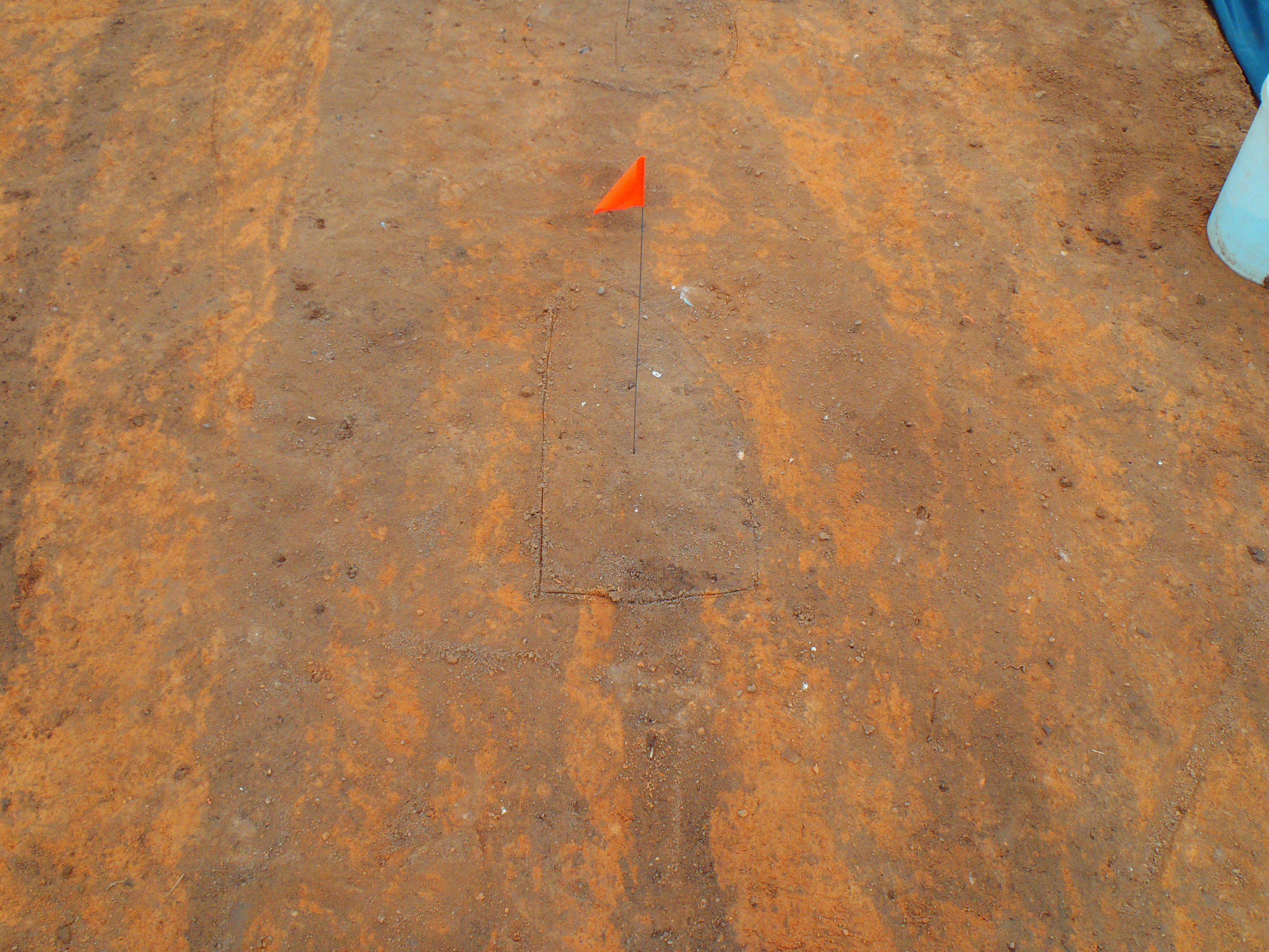
The mysterious pit from above
Written on: July 23rd, 2012 in Archaeology Updates, US301
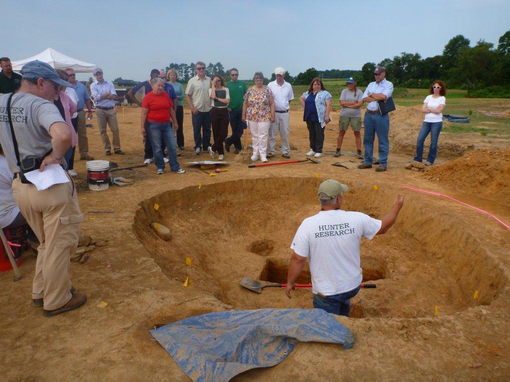
At the Houston Le-Compt site we have met the enemy, and the enemy’s name is……plow scar! Work continued for a third week, and we have moved from digging sample units to mechanically stripping the plow zone from the 0.8-acre site core. After the main house burned in the 1930s, the area became an agricultural field that was plowed, and plowed, and plowed again. This activity left thousands of deep plow scars across the entire site. Plow scars are long shallow troughs left behind when a plow digs deeply into the earth while churning up the soil, leaving a linear dark stain. Plowing over the past 80 years has left an indelible mark on the archaeological record. The deep cross-cutting by the plow ran directly through all of the features left behind by past activity. Sometimes a single feature was cut by a myriad of plow scars, thus almost obliterating its original shape.
Despite very muddled and complex soil conditions, the Dovetail team continued to tease out exciting details on this site. In addition to dozens of post holes, we have located the remains of what may be three buildings, including the root cellar of the main house. Although we have not yet begun excavation of this feature, an abundance of brick, stone and artifacts across this area are a sign of great things to come. Other features we have found include brick piers, what may be a rear yard sheet midden, and a dark stain where many horseshoes were found. Possibly a carriage house that was mentioned in archival records? We will spend the next week finishing our backhoe stripping and creating a site map, with feature excavation beginning in the weeks to come. Now if we can just get past those plow scars.
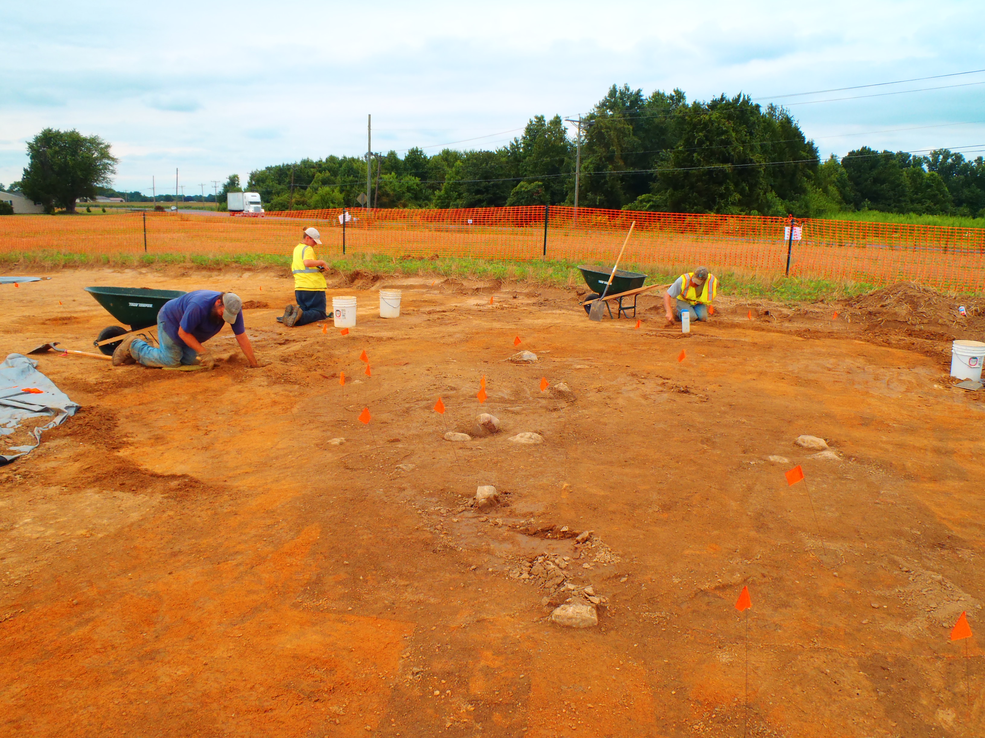
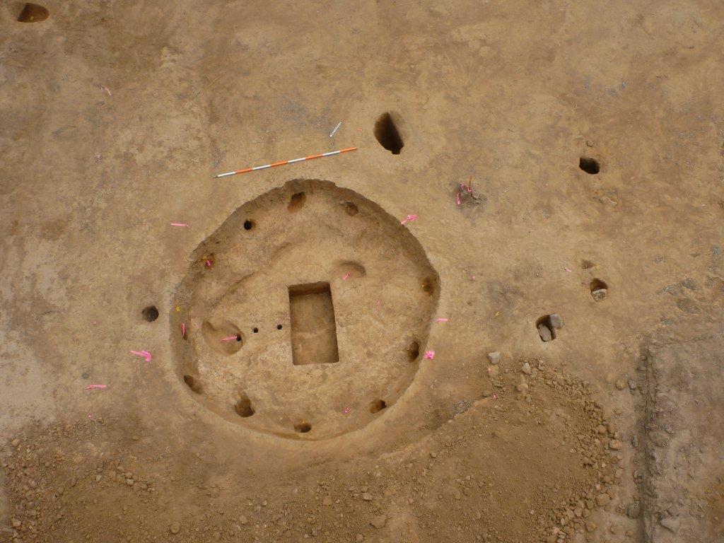
Johnie Sanders, Morgan MacKenzie, and Nathan Sims begin to uncover the root cellar.
Delaware's Governor
State Agencies
Elected Officials
General Assembly
Delaware Courts
State Employees
Cities & Towns
Delaware State Code
State Regulations
Business First Steps
Phone Directory
Locations Directory
Public Meetings
Voting & Elections
Transparency
Delaware Marketplace
Tax Center
Personal Income Tax
Privacy Policy
Weather & Travel
Contact Us
Corporations
Franchise Tax
Gross Receipts Tax
Withholding Tax
Delaware Topics
Help Center
Mobile Apps
E-mail / Text Alerts
Social Media

Built by the Government Information Center
©MMXVIII Delaware.gov

