
Facebook Twitter Flickr YouTube RSS Feed

Written on: July 18th, 2014 in Route 26
Sunday July 20, 2014 through Thursday July 24, 2014
Begin driving sheet piles at the southwest corner of Route 26/Cedar Drive for construction of new modular retaining wall. No lane closures are anticipated for this construction activity.
Continue work on the installation of the new drainage system between Railway Road and Windmill Drive. Motorists should anticipate the eastbound or westbound lane of Route 26 to be closed between Railway Road and Clubhouse Road with traffic alternating through the work zone utilizing a flagging operation on Sunday between 10:30 p.m. and 07:00 a.m. and Monday through Thursday between 8:00 p.m. and 07:00 a.m.
Continue installation of new drainage system between Woodland Avenue and West Avenue. Motorists should anticipate eastbound or westbound lane closures on Route 26 between West Avenue and Woodland Ave with traffic alternating through the work zone utilizing a flagging operation as well as lane closures on Central Avenue at Route 26 with traffic alternating through the intersection utilizing a flagging operation by law enforcement and construction personnel on Sunday between 10:30 p.m. and 07:00 a.m. and Monday through Thursday between 8:00 p.m. and 07:00 a.m.
Continue work on the installation of the new drainage system between Cedar Drive and Grants Avenue. Motorists should anticipate the eastbound or westbound lane of Route 26 to be closed between Cedar Drive and Grants Avenue with traffic alternating utilizing a flagging on Sunday between 10:30 p.m. and 07:00 a.m. and Monday through Thursday between 8:00 p.m. and 07:00 a.m.
Continue excavation of Storm Water Management Pond #332 located west of Route 17 (Roxana Road) and Storm Water Management Pond #333 located at Windmill Drive and Route 26. No lane closures are anticipated for these construction activities.
Sunday July 27, 2014 through Thursday July 31, 2014
Begin installation of well points along the south side of Route 26 for sanitary sewer line expansion, west of Irons Lane. No lane closures are anticipated for these construction activities.
Continue driving sheet piles at the southwest corner of Route 26/Cedar Drive for construction of new modular retaining wall. No lane closures are anticipated for this construction activity.
Continue work on the installation of the new drainage system between Railway Road and Windmill Drive. Motorists should anticipate the eastbound or westbound lane of Route 26 to be closed between Railway Road and Clubhouse Road with traffic alternating through the work zone utilizing a flagging operation on Sunday between 10:30 p.m. and 07:00 a.m. and Monday through Thursday between 8:00 p.m. and 07:00 a.m.
Continue installation of new drainage system between Woodland Avenue and West Avenue. Motorists should anticipate eastbound or westbound lane closures on Route 26 between West Avenue and Woodland Ave with traffic alternating through the work zone utilizing a flagging operation as well as lane closures on Central Avenue at Route 26 with traffic alternating through the intersection utilizing a flagging operation by law enforcement and construction personnel on Sunday between 10:30 p.m. and 07:00 a.m. and Monday through Thursday between 8:00 p.m. and 07:00 a.m.
Continue work on the installation of the new drainage system between Cedar Drive and Grants Avenue. Motorists should anticipate the eastbound or westbound lane of Route 26 to be closed between Cedar Drive and Grants Avenue with traffic alternating utilizing a flagging on Sunday between 10:30 p.m. and 07:00 a.m. and Monday through Thursday between 8:00 p.m. and 07:00 a.m.
Continue excavation of Storm Water Management Pond #332 located west of Route 17 (Roxana Road) and Storm Water Management Pond #333 located at Windmill Drive and Route 26. No lane closures are anticipated for these construction activities.
Written on: July 18th, 2014 in Route 26
After careful review of the Transportation Management Plan that was developed as part of the SR 26 Mainline Project to assist in identifying the impacts of the construction of the SR 26 Mainline Project to the community and the traveling public, the Construction Management Team has decided to implement the following change to the lane closure restriction schedule. This change to the allowable lane closure schedule was made in an effort to minimize impacts to the community and the traveling public.
Since the implementation of night time lane closures on May 21, 2014, Construction Inspection staff have been closely monitoring traffic delays, specifically traffic queues and wait times during flagging operations immediately after setting up the lane closures. On numerous occasions throughout the first half of the “on-peak” season, traffic queues with clearance times in excess of one hour have been observed. In addition to the observations made by the Construction Inspection staff, the SR 26 Mainline Construction Management Team has received concerns from both area businesses and residents.
Beginning Monday, July 21, 2014, the start of night time lane closures will be pushed back one full hour. Construction crews will be permitted to close lanes of SR 26 each night from 8:00 PM to 07:00 AM, Monday through Friday morning.
Written on: July 11th, 2014 in Route 26
One lane of Route 26 will be closed early Saturday morning for emergency roadwork. Motorists should anticipate the westbound lane of Route 26 to be closed between Railway Road and Clubhouse Road with traffic alternating through the work zone utilizing a flagging operation between 12 a.m. and 7 a.m.
This emergency roadwork condition is the result of the heavy rains that the area has received during the past three nights. Please plan to utilize an alternate route around this area if you need to travel on Route 26 between 12 a.m. and 7 a.m. on Saturday, July 12.
Written on: July 3rd, 2014 in Route 26
Monday, July 7, 2014, through Friday, July 11, 2014
Begin work on the installation of the new drainage system between Railway Road and Clubhouse Road. Motorists should anticipate the eastbound or westbound lane of Route 26 to be closed between Railway Road and Clubhouse Road with traffic alternating through the work zone utilizing a flagging operation between 7:00 p.m. and 06:00 a.m.
Continue reconstruction of the Old Mill Road/Route 26 intersection. Motorists should anticipate lane closures at Old Mill Road and Route 26 with traffic alternating through the intersection utilizing a flagging operation by law enforcement and construction personnel between 7:00 p.m. and 06:00 a.m.
Continue reconstruction of the Central Avenue/Route 26 intersection and water main relocation work between Woodland Avenue and Central Avenue. Motorists should anticipate eastbound or westbound lane closures on Route 26 between West Avenue and Woodland Ave with traffic alternating through the work zone utilizing a flagging operation between 7:00 p.m. and 06:00 a.m. as well as lane closures on Central Avenue at Route 26 with traffic alternating through the intersection utilizing a flagging operation by law enforcement and construction personnel between 7:00 p.m. and 06:00 a.m.
Continue work on the installation of the new drainage system between Cedar Drive and Grants Avenue. Motorists should anticipate the eastbound or westbound lane of Route 26 to be closed between Cedar Drive and Grants Avenue with traffic alternating utilizing a flagging operation between 07:00 p.m. and 6:00 a.m.
Continue excavation of Storm Water Management Pond #332 located east of Route 17 (Roxana Road) during the day. No lane closures are anticipated for this work.
Continue excavation of Storm Water Management Pond #333 located at Windmill Drive and Route 26. No lane closures are anticipated for this week.
Monday July 14, 2014 through Friday July 18, 2014
Continue the installation of the new drainage system between Railway Road and Clubhouse Road. Motorists should anticipate the eastbound or westbound lane of Route 26 to be closed between Railway Road and Clubhouse Road with traffic alternating through the work zone utilizing a flagging operation between 7:00 p.m. and 06:00 a.m.
Continue work on the installation of the new drainage system between Cedar Drive and Grants Avenue. Motorists should anticipate the eastbound or westbound lane of Route 26 to be closed between Cedar Drive and Grants Avenue with traffic alternating utilizing a flagging operation between 07:00 p.m. and 6:00 a.m.
Continue reconstruction of the Old Mill Road/Route 26 intersection. Motorists should anticipate lane closures at Old Mill Road and Route 26 with traffic alternating through the intersection utilizing a flagging operation by law enforcement and construction personnel between 7:00 p.m. and 06:00 a.m.
Continue reconstruction of the Central Avenue/Route 26 intersection and the installation of the new drainage system between Woodland Avenue and Central Avenue. Motorists should anticipate eastbound or westbound lane closures on Route 26 between West Avenue and Woodland Ave with traffic alternating through the work zone utilizing a flagging operation between 7:00 p.m. and 06:00 a.m. as well as lane closures on Central Avenue at Route 26 with traffic alternating through the intersection utilizing a flagging operation by law enforcement and construction personnel between 7:00 p.m. and 06:00 a.m.
Continue excavation of Storm Water Management Pond #332 located east of Route 17 (Roxana Road) during the day. No lane closures are anticipated for this work.
Continue excavation of Storm Water Management Pond #333 located east of Route 17 (Roxana Road) during the day. No lane closures are anticipated for this work.
Written on: July 1st, 2014 in Route 26
On Wednesday, July 2, 2014, one lane of Powell Farm Road south of Route 26 will be closed for construction activities. George & Lynch, Inc. of Dover, Delaware will be performing grading activities adjacent to the edge of the travel lane along Powell Farm Road, south of Route 26.
Motorists should anticipate the northbound or southbound lane of Powell Farm Road to be closed between 07:00 a.m. – 5:00 p.m. with traffic alternating through the work zone utilizing a flagging operation. Motorists are reminded that Route 26 will remain open at all times during these construction activities.
Written on: June 30th, 2014 in Route 26
Monday June 30, 2014 through Thursday July 3, 2014
Begin minor grading activities at Omar Road and Route 26. No lane closures are anticipated for this work.
Begin excavation of Storm Water Management Pond #333 located at Windmill Drive and Route 26. No lane closures are anticipated for this work.
Continue reconstruction of the Central Avenue/Route 26 intersection and water main relocation work between Woodland Avenue and Central Avenue. Motorists should anticipate eastbound or westbound lane closures on Route 26 between West Avenue and Woodland Ave with traffic alternating through the work zone utilizing a flagging operation between 7:00 p.m. and 06:00 a.m. as well as lane closures on Central Avenue at Route 26 with traffic alternating through the intersection utilizing a flagging operation by law enforcement and construction personnel between 7:00 p.m. and 06:00 a.m.
Continue work on the installation of the new drainage system between Old Mill Road and Clubhouse Road. Motorists should anticipate the eastbound or westbound lane of Route 26 to be closed between Old Mill Road and Wind Mill Drive with traffic alternating through the work zone utilizing a flagging operation between 7:00 p.m. and 06:00 a.m.
Continue excavation of Storm Water Management Pond #332 located east of Route 17 (Roxana Road) during the day. No lane closures are anticipated for this work.
Continue reconstruction of the Old Mill Road/Route 26 intersection. Motorists should anticipate lane closures at Old Mill Road and Route 26 with traffic alternating through the intersection utilizing a flagging operation by law enforcement and construction personnel between 7:00 p.m. and 06:00 a.m.
Monday July 7, 2014 through Friday July 11, 2014
Continue minor grading activities at Omar Road and Route 26. No lane closures are anticipated for this work.
Continue excavation of Storm Water Management Pond #333 located at Windmill Drive and Route 26. No lane closures are anticipated for this work.
Continue reconstruction of the Central Avenue/Route 26 intersection and water main relocation work between Woodland Avenue and Central Avenue. Motorists should anticipate eastbound or westbound lane closures on Route 26 between West Avenue and Woodland Ave with traffic alternating through the work zone utilizing a flagging operation between 7:00 p.m. and 06:00 a.m. as well as lane closures on Central Avenue at Route 26 with traffic alternating through the intersection utilizing a flagging operation by law enforcement and construction personnel between 7:00 p.m. and 06:00 a.m.
Continue work on the installation of the new drainage system between Old Mill Road and Windmill Drive. Motorists should anticipate the eastbound or westbound lane of Route 26 to be closed between Old Mill Road and Wind Mill Drive with traffic alternating through the work zone utilizing a flagging operation between 7:00 p.m. and 06:00 a.m.
Continue excavation of Storm Water Management Pond #332 located east of Route 17 (Roxana Road) during the day. No lane closures are anticipated for this work.
Written on: June 24th, 2014 in Route 26
On Thursday, June 26, 2014 and Friday, June 27, 2014, one lane of Powell Farm Road south of Route 26 will be closed for construction activities. George & Lynch, Inc. of Dover, Delaware will be performing roadway widening activities along Powell Farm Road, south of Route 26.
Motorists should anticipate the northbound or southbound lane of Powell Farm Road to be closed daily beginning at 9:00 a.m. with traffic alternating through the work zone utilizing a flagging operation. Motorists are reminded that Route 26 will remain open at all times during these construction activities. All construction activities will be completed by 3:00 p.m. on Friday, June 27, 2014.
Written on: June 20th, 2014 in Route 26
Monday June 23, 2014 through Friday June 27, 2014
Continue reconstruction of the Central Avenue/Route 26 intersection. Motorists should anticipate eastbound or westbound lane closures on Route 26 between West Avenue and Woodland Ave with traffic alternating through the work zone utilizing a flagging operation between 7:00 p.m. and 06:00 a.m. as well as lane closures on Central Avenue at Route 26 with traffic alternating through the intersection utilizing a flagging operation by law enforcement and construction personnel between 7:00 p.m. and 06:00 a.m.
Continue reconstruction of the Old Mill Road/Route 26 intersection. Motorists should anticipate lane closures at Old Mill Road and Route 26 with traffic alternating through the intersection utilizing a flagging operation by law enforcement and construction personnel between 7:00 p.m. and 06:00 a.m.
Continue work on the installation of the new drainage system between Cedar Drive and Old School Lane. Motorists should anticipate the eastbound or westbound lane of Route 26 between Old Mill Road and Old School Lane to be closed with traffic alternating through the work zone utilizing a flagging operation between 7:00 p.m. and 06:00 a.m.
Continue excavation of Storm Water Management Pond #332 located east of Route 17 (Roxana Road) during the day. No lane closures are anticipated for this work.
Continue excavation of Storm Water Management Pond #331 located west of Irons Lane. No lane closures are anticipated for this work.
Begin water main relocation work between Woodland Avenue and Central Avenue. Motorist should anticipate shoulder closures along Route 26 from Woodland Avenue to Central Avenue between 7:00 p.m. and 06:00 a.m.
Monday June 30, 2014 through Thursday July 3, 2014
Continue water main relocation work between Woodland Avenue and Central Avenue. Motorist should anticipate shoulder closures along Route 26 from Woodland Avenue to Central Avenue between 7:00 p.m. and 06:00 a.m.
Continue reconstruction of the Old Mill Road/Route 26 intersection. Motorists should anticipate lane closures at Old Mill Road and Route 26 with traffic alternating through the intersection utilizing a flagging operation by law enforcement and construction personnel between 7:00 p.m. and 06:00 a.m.
Continue work on the installation of the new drainage system between Old Mill Road and Clubhouse Road. Motorists should anticipate the eastbound or westbound lane of Route 26 to be closed between Old Mill Road and Clubhouse Road with traffic alternating through the work zone utilizing a flagging operation between 7:00 p.m. and 06:00 a.m.
Continue reconstruction of the Central Avenue/Route 26 intersection. Motorists should anticipate eastbound or westbound lane closures on Route26 between West Avenue and Woodland Ave with traffic alternating through the work zone utilizing a flagging operation between 7:00 p.m. and 06:00 a.m. as well as lane closures on Central Avenue at Route 26 with traffic alternating through the intersection utilizing a flagging operation by law enforcement and construction personnel between 7:00 p.m. and 06:00 a.m.
Continue excavation of Storm Water Management Pond #332 located east of Route 17 (Roxana Road) during the day. No lane closures are anticipated for this work.
Continue excavation of Storm Water Management Pond #331 located west of Irons Lane. No lane closures are anticipated for this work.

Written on: June 17th, 2014 in Archaeology Updates, US301
The Report on the Analysis of Flotation-recovered and Hand-collected Archeobotanical Remains from the Elkins Sites (7NC-G-174),
New Castle County, Delaware. Phase III Archaeological Data Recovery by Justine McKnight, Archeobotanical Consultant to Hunter Research, Inc. has yielded some very interesting results which contribute significantly to the archaeological record in Delaware.
INTRODUCTION
Phase III archaeological data recovery at the Elkins Sites (7NC-G-174) in New Castle County, Delaware, was conducted by Hunter Research, Inc. as part of the Delaware Department of Transportation’s U.S. Route 301 Development Project. The Elkins Site complex comprises the Elkins A site, the Elkins Burial site and the Elkins B site – three discrete but closely tied archaeological components with historic occupations focused during the eighteenth century. Elkins A describes a domestic site occupied from ca. 1740 to ca. 1780 that overlies a prehistoric occupation. The Elkins Burial component describes a small cemetery plot containing five individuals preliminarily dated to the late 17th or early 18th century. The Elkins B component is a briefly occupied historic site in use from the mid-1720’s through the early 1730’s. A prehistoric component has also been identified at Elkins B.
Research goals of the data recovery effort include exploration of the relationship between the three site components, definition of cultural occupancy and ethnicity, delineation of landscape and exploration of site economies. Excavated features yielded carbonized plant macro-remains which relate directly to these research themes. Importantly, archeobotanical data from the Elkins Sites contribute to the regional archeobotanical dataset.
SUMMARY OF THE RESULTS
Some particularly notable features were excavated at the Elkins sites: The domestic cellar at Elkins B produced the richest deposits of macro-botanical remains (99.6 percent of the total carbon recovered through flotation at Elkins B). Recovered remains included concentrations of field crops (wheat, wheat/oat, maize, pea, bean), fruits (peach, cherry, grape), weedy growth (sedge), and morning glory (Ipomoea sp.) which may have been employed as a medicinal or ornamental plant. Wood charcoal (oaks and hickory) recovered from the Elkins B cellar likely represents the remains of fuel wood. Each of these is a high-calorie wood that would have been locally abundant (Graves 1919). The Wolf Pit feature identified at Elkins A presents a regionally unique feature type. Analysis of one flotation sample and five hand-collected carbon samples were scrutinized from this feature. Archeobotanical remains from the Wolf Pit were limited to wood charcoal. Pine was the most abundant wood type identified, followed by hickory. Unidentifiable deciduous species were also recorded. While not definitive, the recovery of these taxa from the pit may reveal details of trap construction.
Archeobotanical remains from the Elkins sites derive from 16 flotation samples and 34 hand collected samples. A variety of economically important cultivated and wild plant resources were documented within the assemblage. A rigorous program of soil flotation (approximately 651 liters) and hand-collected carbon samples produced historically significant plant macro-fossils, including wood charcoal, a range of field crops (including bean, wheat, maize and peas), cultivated fruit pits and seeds, limited evidence of medicinal and ornamental plants, along with vegetal miscellany. The results from the large domestic cellar excavated at Elkins B were particularly informative, providing strong evidence for a working farmstead where the cultivation of field crops and orchards were important pursuits.
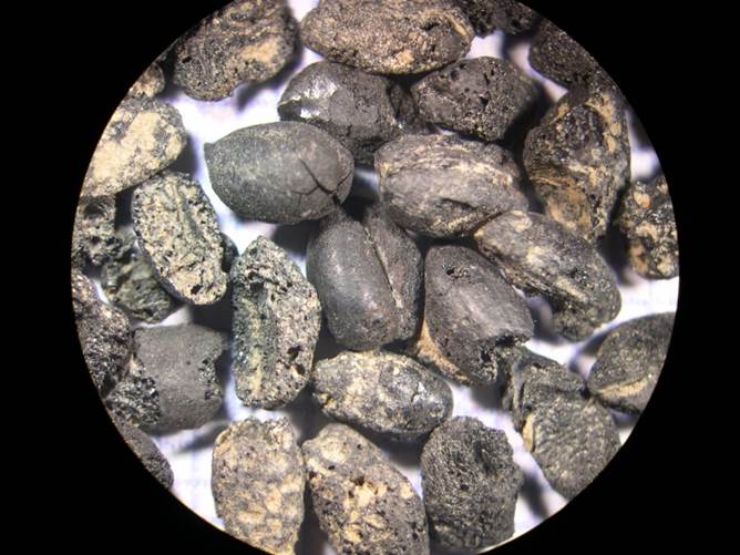
Charred wheat kernels from Elkins B Cellar hole.
Written on: June 17th, 2014 in Archaeology Updates, US301
Identification and AMS Radiocarbon Dating of Charcoal and Botanic Samples From the Elkins B Site (7NC-G-174) in New Castle County, Delaware
By Peter Kovacik with assistance from R. A. Varney of Paleo Research Institute, Golden, Colorado for Hunter Research, Inc.
This report provides carbon 14 dates for five prehistoric pits features from the Elkins B site excavated by Hunter Research, Inc.
Context 514 dates to the Middle Archaic Period
Context 518 dates to the Woodland I – Middle Woodland Period
Context 520 dates to the end of the Woodland I – Middle Woodland Period
Context 536 dates to the end of the Woodland II Period – Early Contact Period
Context 528 dates from circa AD 1730 to AD 1810
Of note: Context 528 which dates to circa 1730 to 1810 was located approximately 40 feet west of the Elkins B cellar hole which dates from the mid-1720’s through the early 1730’s falls within the early part of the range but contained no historic artifacts and in fact exhibited all of the characteristics of a prehistoric storage pit. Preliminary examination of the material culture has suggested the occupants of Elkins B may have included an assimilated Native American. This site contains very few subsurface features, so perhaps if a Native American was living there a combination of European and traditional Native American traits were employed at this site. Below is a table with the raw and calibrated data from the five pit features.
RADIOCARBON RESULTS FOR SAMPLES FROM
THE ELKINS B SITE (7NC-G-174) IN NEW CASTLE COUNTY, DELAWARE
|
Sample No. |
Sample
Identification |
AMS 14C Date* |
1-sigma Calibrated Date (68.2%) | 2-sigma Calibrated Date (95.4%) | δ13C**
(o/oo) |
|
PRI-14-030-528 |
Quercus – Erythrobalanus group charcoal | 188 ± 22
RCYBP |
290–260;
220–140; 20–(‑11) CAL yr. BP |
300–260;
220–140; 30–(‑11) CAL yr. BP |
-25.1 |
| AD 1660–1690
AD 1730–1810 AD 1930–1960 |
AD 1650–1690
AD 1730–1810 AD 1920–1960 |
||||
|
PRI-14-030-536 |
Quercus – Erythrobalanus group charcoal | 319 ± 21
RCYBP |
430–350;
340–310 CAL yr. BP |
460–300
CAL yr. BP |
-25.5 |
| AD 1520–1600
AD 1610–1640 |
AD 1490–1650 | ||||
|
PRI-14-030-520 |
Carya nutshell, charred | 1479 ± 22
RCYBP |
1390–1340
CAL yr. BP |
1405–1315
CAL yr. BP |
-24.5 |
| AD 560–610 | AD 545–635 | ||||
|
PRI-14-030-518 |
Quercus -Leucobalanus group charcoal | 1955 ± 22
RCYBP |
1930–1875
CAL yr. BP |
1970–1860; 1850–1820
CAL yr. BP |
-26.4 |
| AD 20–75 | 20 BC–AD 90
AD 100–130 |
||||
|
PRI-14-030-514 |
Carya nutshell, charred | 6328 ± 25
RCYBP |
7310–7240; 7200–7170
CAL yr. BP |
7320–7170
CAL yr. BP |
-24.3 |
| 5360–5290 BC 5250–5220 BC | 5370–5220 BC |
* Reported in radiocarbon years at 1 standard deviation measurement precision (68.2%),
corrected for δ13C.
** δ13C values are measured by AMS during the 14C measurement. The AMS-δ13C values
are used for the 14C calculation and should not be used for dietary or
paleoenvironmental interpretations.
Delaware's Governor
State Agencies
Elected Officials
General Assembly
Delaware Courts
State Employees
Cities & Towns
Delaware State Code
State Regulations
Business First Steps
Phone Directory
Locations Directory
Public Meetings
Voting & Elections
Transparency
Delaware Marketplace
Tax Center
Personal Income Tax
Privacy Policy
Weather & Travel
Contact Us
Corporations
Franchise Tax
Gross Receipts Tax
Withholding Tax
Delaware Topics
Help Center
Mobile Apps
E-mail / Text Alerts
Social Media

Built by the Government Information Center
©MMXVIII Delaware.gov

