
Facebook Twitter Flickr YouTube RSS Feed

Written on: July 17th, 2012 in Archaeology Updates, US301
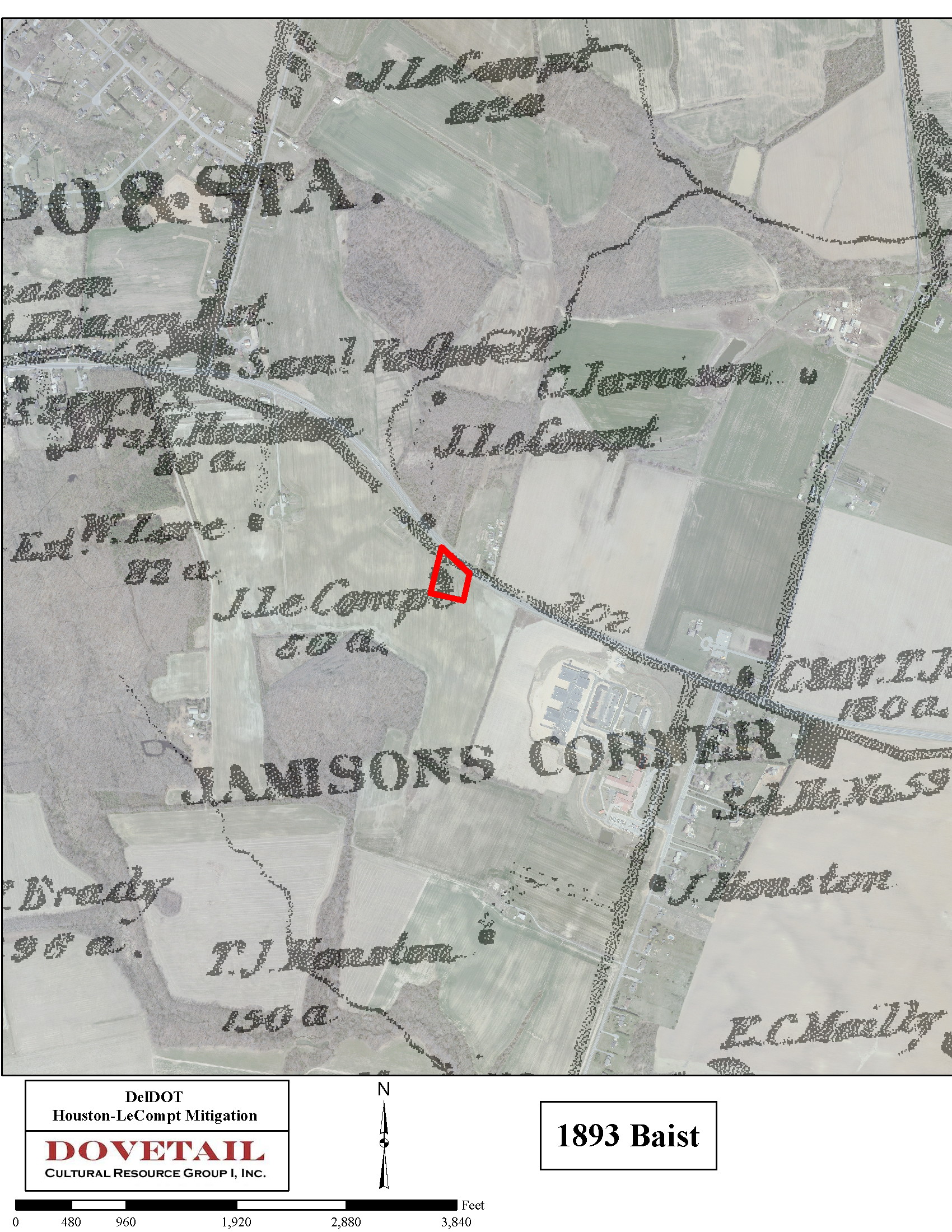
Excavation of the Houston-LeCompt site made great progress this week thanks to the crew’s hard work and much nicer weather since our last update. Our process of sampling the plowzone using ten 2×2 meter units is complete! We have sent over 6,500 artifacts to the lab to keep them busy washing, sorting, and analyzing already. Yikes! We are particularly excited to hear back from them about some specific items we found, including jewelry, ceramic doll parts, and several coins. We also started our next big task, which is removing the plowzone from the rest of the site using heavy equipment. Even at the bottom of our sample units we were finding features, and as the heavy equipment get closer to the foundation area located during the site evaluation, we expect to be finding a lot more. Along with the archaeology, we have also continued to do archival research and GIS mapping of the site. What we have found so far is already helping us to rethink the history of this site. It now appears that the circa 1770s Houston house may have been located west of our site, and we are uncovering the remains of a mid-19th century home instead. The house, built either by Richard Mulford or James LeCompt, was used as a tenant house in the late-19th century. We used GIS mapping and completed a study called “georeferencing”–tying historic maps to modern features and aerials through an overlaying process using specific geographic features as references)–to aid in this identification. Maps from 1849, 1868, and 1893 are helping us with site interpretation, and the marriage of these documents and archaeological finds is coming together very nicely thus far!
This coming week we are upgrading to even heavier equipment. A larger backhoe will help us remove the plowzone faster and get the crew back to what we all love doing as archaeologists, playing in the dirt! Our goal is to have the site completely cleared during our next eight-day work week, so that we can focus the rest of our time on investigating the subsurface features that are revealed. We are all looking forward to finding out what the root cellar fill has been holding for the last hundred or so years, just waiting for us to find it again.
Written on: July 17th, 2012 in Archaeology Updates, US301
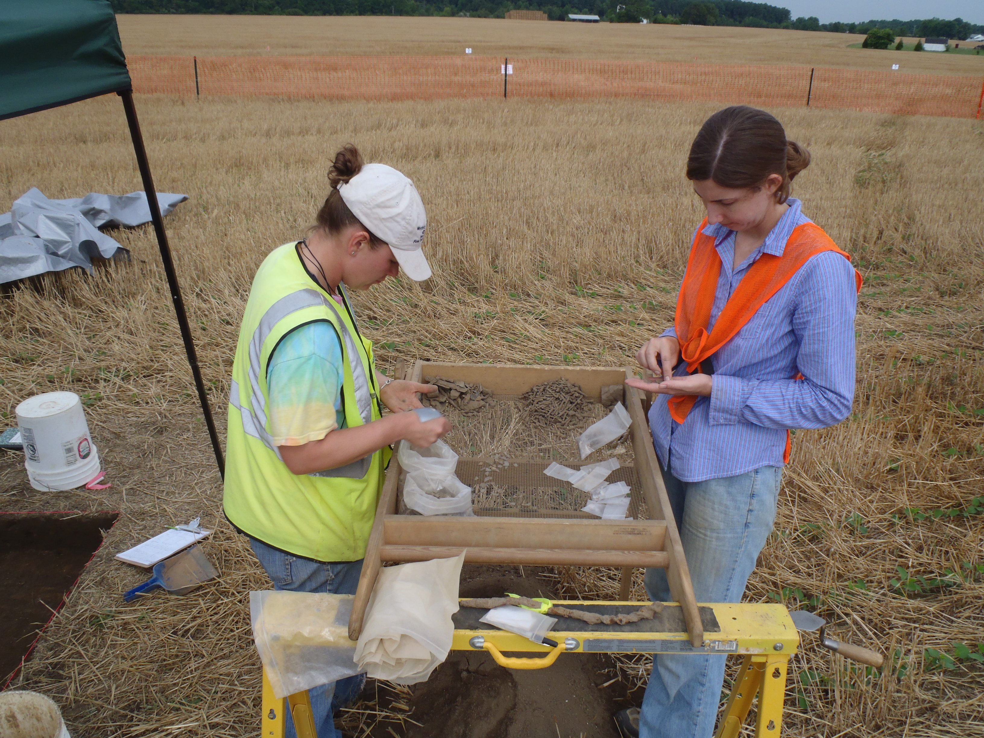
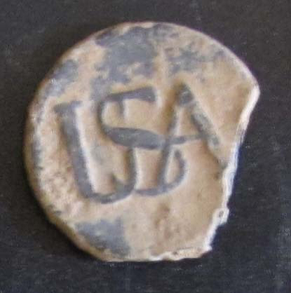
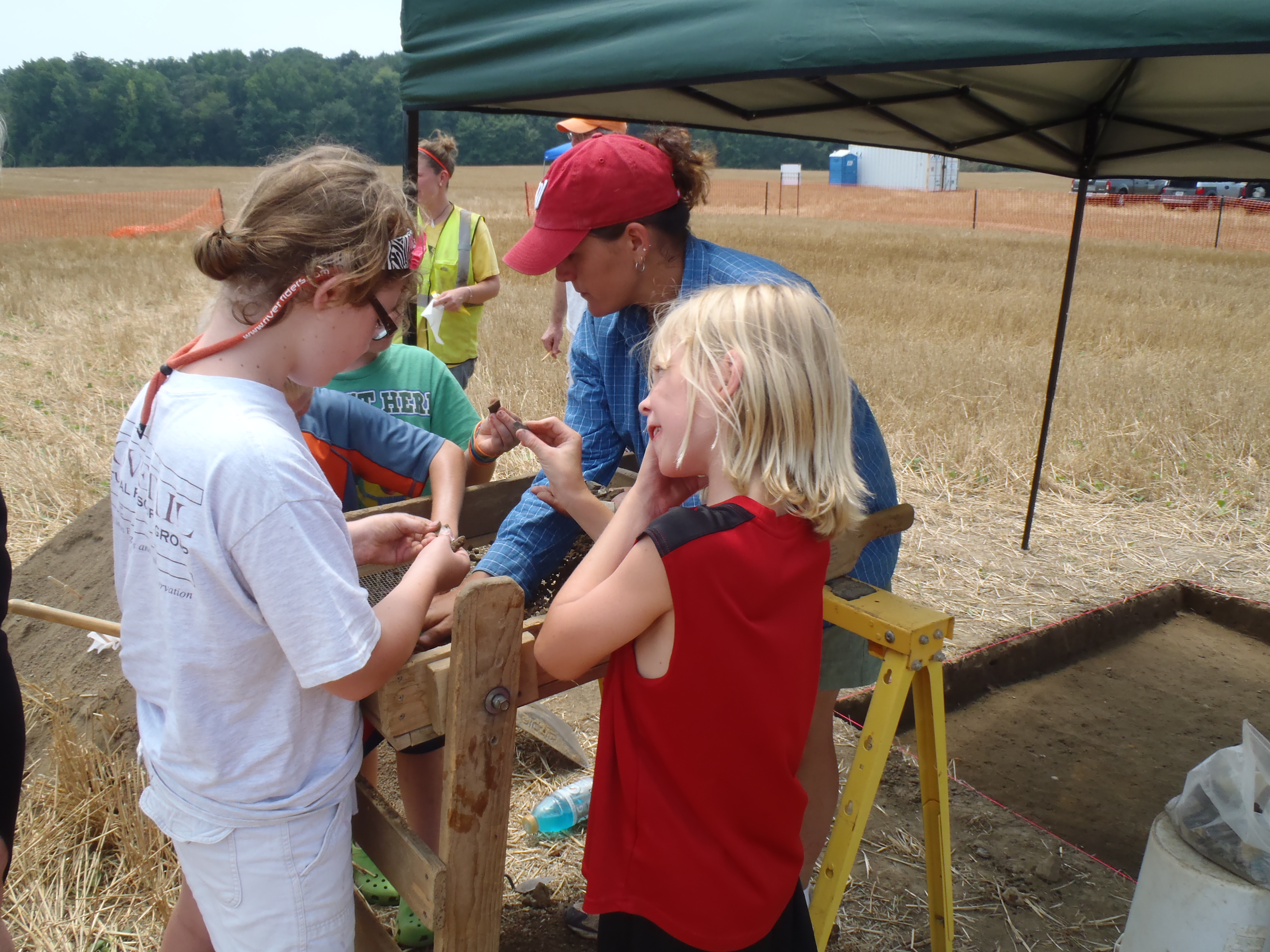
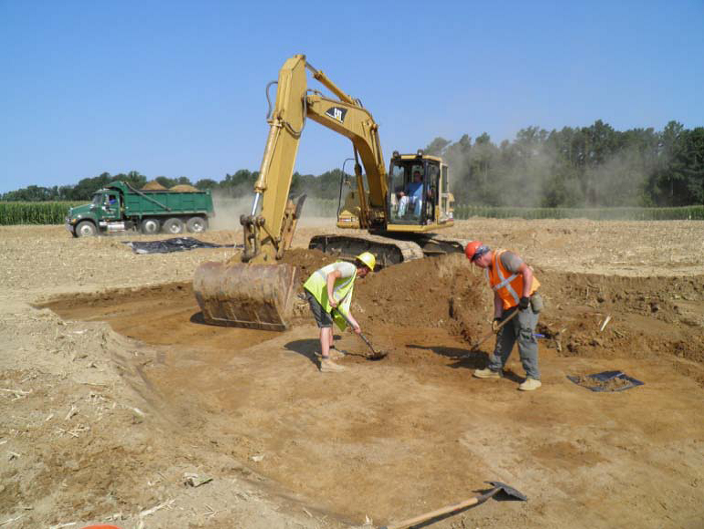 The first week of the Rumsey-Polk Tenant-Prehistoric site Phase III archaeological fieldwork excavation was off with a bang… and a clang – of the big mechanical excavator! To our surprise, traces of over 120 stains, pits, posts, and wells, otherwise known as “features,” have been found in the northern part of the site. Features like these can tell us a lot about the people who once called the site “home.” We expect to find many more exciting features as we move south to excavate near the former house in the coming weeks. The former residents of the site included prehistoric Native Americans, and later was occupied by tenants of the Rumsey, Polk, and Cochran families between 1740 and 1855. Along with using an excavator to remove about one acre of topsoil to search for features, our crew has also worked hard through the summer heat, sifting soil from several areas of the site to find artifacts that once belonged to the site’s occupants. Artifact of the week (below) is a pewter “USA” Continental Army button worn by a Revolutionary War soldier sometime between 1775 and 1783.
Written on: July 9th, 2012 in Archaeology Updates, US301
Work this week at the Elkins site concentrated on feature excavations. Situated near the base of the knoll on which the stone-lined root-cellar lies is a low un-mortared wall consisting of limonite and local cobbles. This wall traverses and blocks a now-shallow gully that eventually drains into Scott Run. Soils situated on the downstream side of the wall consist of sorted sands, while soils located on the upper side consist of finer sands and silts, suggesting they had settled out from an impound of water. We believe the people who lived on the knoll built this damn to hold back water either from a natural spring head or from rainwater passing down a gully leading to Scott Run. This impound would have provided drinking water for their livestock.
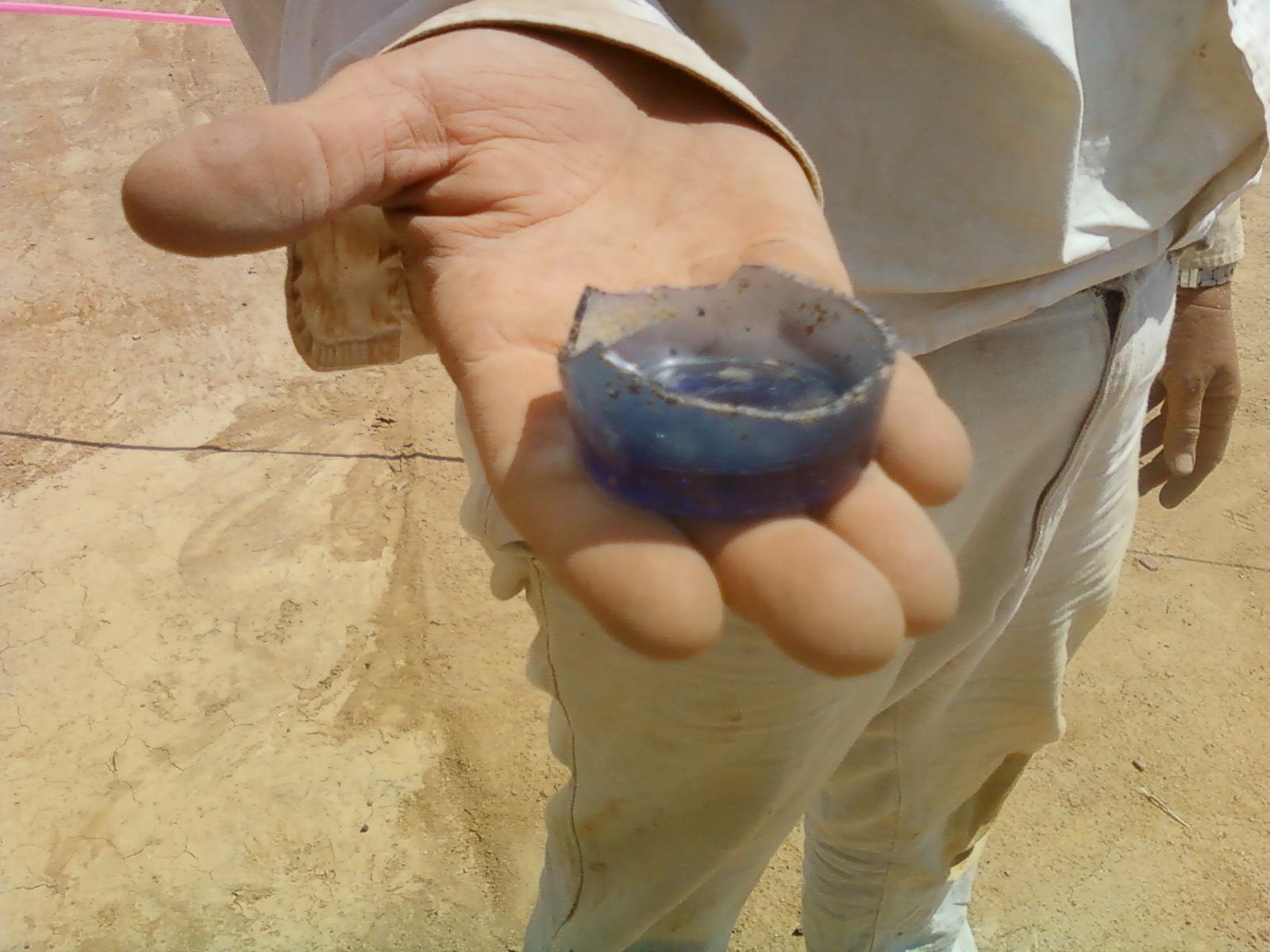
West of the cellar hole, the small sunken-floored building described last week appears to be an out-kitchen, based on the evidence of numerous bone fragments, oyster shells and utilitarian ceramic red earthenware sherds from its floor. Out-kitchens are separate structures situated near a house built to prepare and cook food without heating up the house during the warmer months, hence they area also known as summer kitchens. We currently estimate that this out-kitchen was 16 feet long by 8 feet wide. The nearby stone-lined root-cellar hole now appears to lie within the center of a building measuring 16 feet wide by 16 to 24 feet long. These measurements are based on the absence of gravel at the bottom of the plowzone around the root-cellar. Excavations within the northern portion of the root-cellar recovered the base of a light cobalt “flip glass”, also known as a tumbler (Photo). Other high quality artifacts recovered from the root-cellar continue to suggest the people who once lived there were either wealthy or had access to expensive items. One of the continuing debates among archaeologists studying the 18th century is when and how a “consumer” society developed in the American Colonies: a society in which people became interested in defining themselves more by the things they owned than in more traditional means of showing status such as social class and landownership. Our 301 sites look set to contribute to that debate.
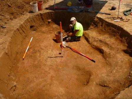
The feature we have for some time considered to be a well, located 45 feet from the root-cellar, has now become one of the most puzzling features at the site, and possibly on the Route 301 project to date. This circular feature is situated on the side of the shallow gully that defines the northern boundary of the homestead. The feature measures approximately 14 feet in diameter and extends three feet below the plowzone (Photo). There are large posts positioned approximately every three feet around the perimeter. Each post rests on a rock to prevent it from rotting. The slabs situated in the middle exhibit signs of trimming or shaping. They are formed from a light green sandstone whose origin is unknown…for now. No other artifacts have been recovered from this enigmatic feature. The lack of artifacts suggest that it may predate the house, as otherwise household refuse would have undoubted been part of the upper fill. So what is it? We have ruled out a well, privy, cistern, spring head, windmill, or silo. One exciting suggestion is that it is a wolf trap. Construction of wolf traps was mandated in this area during the 1680s and 1690s as attempts were made to eradicate wolves as pests. The small crossroads settlement of McDonough, a couple of miles south on what is now Route 13, was originally called “Trap”. Your thoughts, as always, are welcome.
Written on: July 9th, 2012 in Archaeology Updates, US301
We are beginning another excavation on the 301 project! Here is the link to a handout detailing this amazing site.
https://deldot.gov/environmental/archaeology/houston-lecompt/pdf/handout.pdf

Fieldwork has begun at the Houston-LeCompt archaeological site despite the hot weather. One good thing to come out of the recent storms is that the rain left us with good workable soil conditions. That makes a huge difference when digging in this heat! We are about halfway through the process of sampling the plowzone for artifacts. Recovery so far has been very heavy in most of our sample areas, with thousands of fragments of historic ceramics and glassware making up the bulk. While is is sad that so many beautiful objects were broken up by centuries of plowing, it is a testament to how long and how frequently farmers have been working this land. Among those thousand of objects, there are also a few gems, such as half of a tiny teacup from a child’s tea set, a thimble, pennies from the late 1800’s, and a hair pin set. However, it is what is at the bottom of our sample units that is exciting to us as archaeologists. We are seeing features underneath the plowzone, around the area where the foundation and cellar were found during previous work on the site.
Weather permitting, we will finish plowzone sampling early next week, and begin mechanical stripping of the site. We are hoping that once the backhoe starts clearing large areas, the features we can see now will connect to others, possibly to form outlines of additional outbuildings or fence lines, or expand to reveal trash pits, wells, or privies. With the site located right along Boyd’s Corner Road, we have had curious onlookers and visitors stopping by already. We are looking forward to working with volunteers and helping local residents learn more about both the archaeological process and the people who once lived on this farmland.
Written on: July 2nd, 2012 in Archaeology Updates, US301
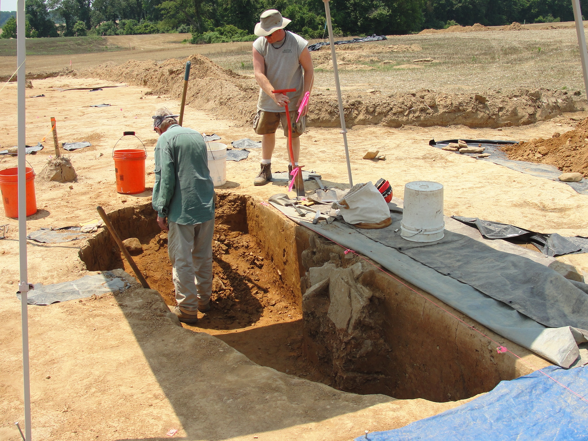
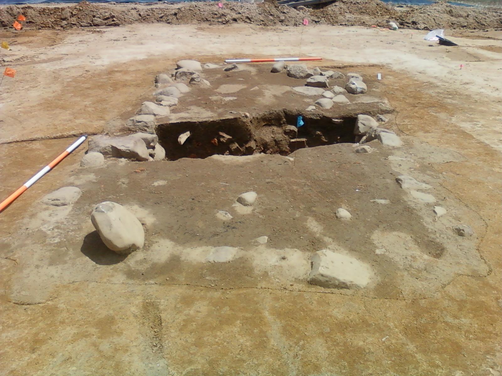
All the machine stripping was completed at the Elkins A site this week, and we are beginning to get an overall picture of the layout of this 18th century homestead. As well as the cellar hole, there are now two other structures, plus lots of pits and posts that we cannot yet make much sense of for the most part. In the northeastern part of the site we have begun excavating the large circular feature identified last week. The photograph shows how we have begun taking the soils out of the southern half of the feature, leaving a vertical profile in place. At this point it looks as if we are looking at the top of a well, with a wide, roughly circular, “cone” sloping down towards the narrower shaft in the center. When the well was filled up someone placed a neat stack of stone slabs, perhaps paving stones, right in the top of the shaft. These are visible on the photo below the white bucket. Probing suggests that the well is at least six feet deep, and we hope for interesting material down at the bottom.

We now also have evidence for a second building on the site. About 20 feet west of the cellar hole we had been examining what we thought was a midden (trash pit). More detailed investigation has now shown that it is in fact a small rectangular building, with a slightly sunken floor and post supports at each end. There is quite a lot of animal bone in the floor material, and this may give us a clue to the function of the structure. It is oriented at 90 degrees to the cellar hole, strongly suggesting the two are contemporary.
The cellar hole itself has provided yet another surprise about our 18th century Delawareans, in the form of a stone with a hole in it. Unlike most of the other stones in the cellar walls, it is not a cobble from the nearby Scott Run, rather it is a quarried stone from an as-yet unknown source. As the photograph shows, there is a very clear straight circular drill hole down one side of the stone. Until compressed-air drills became practicable in the late 1800’s, stone quarrying was usually carried out using the “hammer and tap” method that produces this typical feature on the stone. Typically, two men with sledgehammers hit a steel drill into the rock, while a third man rotated the drill by holding it with a long set of tongs. What this stone is telling us is that somehow a piece of commercially quarried stone somehow found its way to the Elkins site in the mid-18th century. What is the source of the stone? How did it get here? We plan to find out.


Written on: June 27th, 2012 in Route 54
As of June 27, 2012, some additional drainage work is being done to correct some issues that were unforeseen in the original design. This work is expected to be complete July 13th.
The final electrical connections to the signal cabinet bases are being made to activate the new signals.
Work is continuing on the landscaping around the storm water management ponds. Work is ongoing throughout the project limits to clean up debris, remove the silt fence and topsoil and seed adjacent to the curb and sidewalk.
DelDOT thanks everyone for their patience during this construction project.
Written on: June 25th, 2012 in Archaeology Updates, US301
Despite baking heat we continue to expose and document archaeological features at the Elkins A site. The material filling up the cellar hole is now largely removed. There was a mass of bricks in the southern half of the hole, probably collapse from a chimney. One nice find from here is an iron pintle: part of the hinge for a door. We think that the cellar hole was filled in all at one time, presumably when the house was abandoned sometime around 1780. So far we have seen no sign of the house that stood over the cellar. This is disappointing but not surprising. Houses in 18th century Delaware were often log buildings that had little impact on the ground surface, and they were often dismantled and moved to new locations. This may be the case here, but it is hard to be sure yet because we also know that quite a lot of soil (perhaps as much as 1.5 to 2 feet) has eroded away from here since the 18th century, taking some archaeological evidence with it. We will be testing out different ideas as the dig goes on.

Written on: June 20th, 2012 in Archaeology Updates, US301
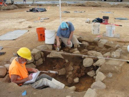
Mother nature relented this week and gave us some much-needed rain. This has softened the soil and made much clearer the color and texture changes that are so critical to dissecting and understanding the site. We have placed sheets of black plastic over the machine-cleared areas to retain the moisture as much as possible. Progress on the machine clearance has been much better as a result of the rain; the field team have been shoveling and trowelling the cleared areas on the Elkins A site. As a result we have found several cultural features that are visible as soil stains. We have not dug into these yet: the job at this point is to identify all the features and only then make decisions about which to excavate fully or sample. The rain was also an opportunity to send some of the team back to our field lab and process some of the artifacts: too many people on a wet site can damage the archaeology.
The machine was not used on the area around the house basement that had been identified in the previous phases of work. Clearance of the plowzone here was done by hand. The result can be seen on the photograph, which shows the exposed filled-up basement of the mid-18th century house. The view is facing to the south. The dark soil filling the rectangular basement is surrounded by the cellar walls which are made of large cobbles, probably brought from the bed of nearby Scott Run. Some of the stones have been dislodged by modern plowing, but the structure is remarkably intact. The trench running across the view is the excavation we did in the Phase II study. We have removed the backfilled soil from this to re-expose the profile across the cellar. In the middle of this trench you can see a circular feature (just left of the blue plastic flagging): this is the Phase I shovel test dug by our colleagues at Archaeological and Historical Consultants which was one of the vital first clues that there was an important site here. The cellar is about 7.5 feet east-west by roughly 15 feet north-south. One of the things we will be trying to establish is whether this feature reflects the size and shape of the house above it, or whether the house was larger and the cellar was only under a part. We have so few examples of other houses of this period from Delaware that either is possible, even though a 7.5 by 15-foot house seems rather small by modern standards!
Written on: June 20th, 2012 in Route 54
As of June 20, 2012, work on the south side related to sidewalks, entrances and handicap ramps is ongoing and is complete. We had a few small sections heave due to the excessive heat that need to be replaced. The replacement will occur the week of June 25.
Work is being performed on some additional drainage work to correct some issues that were unforeseen in the original design. This work is expected to be complete June 29th.
Work is being performed to install the signal detection loops and pedestrian signal poles at each of the signalized intersections. This work is expected to be complete by Friday June 22. Upon completion the final electrical connections to the signal cabinet bases will be made to activate the new signals.
Work is continuing on the landscaping around the storm water management ponds. Work is ongoing throughout the project limits to clean up debris, remove the silt fence and topsoil and seed adjacent to the curb and sidewalk.

Written on: June 19th, 2012 in Indian River Inlet Bridge
DelDOT apologizes for the inconvenience of night work during the removal of the old Indian River Inlet Bridge. Removal of the bridge over the water is safer being performed at night, thus we believe we need to perform that work at this time. Fortunately there are only four other dates when night work will be required. They are tonight June 19, and then again on June 24, 25, 26 and possibly June 27. Future bridge demo work may involve noise, but it will be completed during daytime hours. Again, we apologize for the inconvenience, but are eager to get this work completed. The bridge demolition operation is scheduled to be completed in September 2012.
Delaware's Governor
State Agencies
Elected Officials
General Assembly
Delaware Courts
State Employees
Cities & Towns
Delaware State Code
State Regulations
Business First Steps
Phone Directory
Locations Directory
Public Meetings
Voting & Elections
Transparency
Delaware Marketplace
Tax Center
Personal Income Tax
Privacy Policy
Weather & Travel
Contact Us
Corporations
Franchise Tax
Gross Receipts Tax
Withholding Tax
Delaware Topics
Help Center
Mobile Apps
E-mail / Text Alerts
Social Media

Built by the Government Information Center
©MMXVIII Delaware.gov

