
Facebook Twitter Flickr YouTube RSS Feed

Written on: October 19th, 2012 in Archaeology Updates, US301
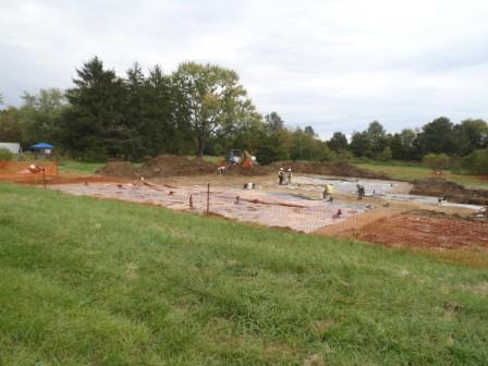
So what happened to the warm weather? Despite a little rain and a lot of wet feet, the Dovetail team continued to work on the Armstrong-Rogers site this past week. Our task? Removing the topsoil from the site core to expose subsurface features. We already knew the area contained at least one building foundation, one other stone feature, and a buried terra cotta drain, but we uncovered several additional exciting finds including a large square feature with brick flecking and several posts and pits. All features were scraped to identify their boundaries and mapped in using a total station. This data was used to create a hand-drawn field map to help organize the remainder of the dig and will also be the basis for a post-field GIS map. Artifacts noted during our topsoil removal continued to span the historic occupation period of the site, from the second half of the eighteenth century through the late-nineteenth century. But while a lot of attention has been paid to the historic artifacts because of the presence of architectural features, the stripping also uncovered evidence of the prehistoric use of this area. A large rim sherd of fabric-impressed, quartz-tempered prehistoric pottery (possibly Hell Island Ware) was found along the western edge of the site. In addition, several possible prehistoric pit features were identified during the scraping. We will add these to our list of features to be excavated in the upcoming weeks. Very exciting!
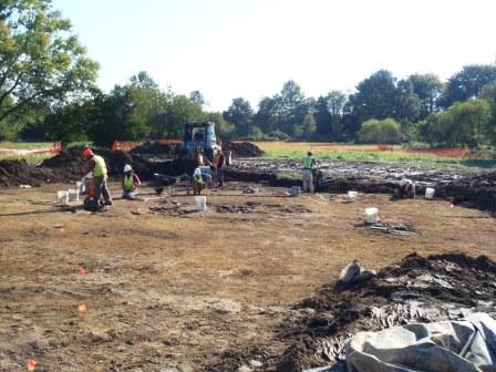 Field crew trowels the stripped area and marks new features revealed by backhoe stripping.
Written on: October 19th, 2012 in Archaeology Updates, US301
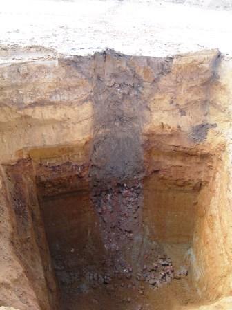
Well, well, well. On the final day of fieldwork at the Rumsey/Polk site, we excavated a deep well. The upper parts of the well , also known as Feature 10, were dug down 5 feet by hand until we reached a layer of lime chunks that were tossed into the abandoned well. The upper parts of the well were filled at the end of the second, circa 1800-1855, tenant period. Some of the interesting artifacts from the feature include a horseshoe, a brass pistol butt cap, plus 18th and 19th-century ceramics like yellowware, engine turned redware, creamware, and annular ware, and whiteware. Wells are fabulous windows to the past; a very interesting way to learn what people were doing and buying, as they typically become deep trash dumps by residents once the well runs dry. Digging a well is no joking matter though since they can be very deep. The deeper you go, the more dangerous it can be to dig. Although the top five feet was dug by hand, we used a backhoe to dig the rest, and boy was it deep! The bottom of the well was reached at 32 feet below ground, the same as the elevation of the creek north of the site. When built during the 18th or 19th century, the well was dug by hand. Each well posed a danger of collapsing on the workmen. Some wells were dug 40 feet deep just to reach water. This really makes you appreciate the effort and danger associated with well digging during the 18th and 19th centuries. While digging the well, the backhoe carefully removed each soil layer, which the crew screened for artifacts. As you can see in the photograph, more than half of the well was filled with broken brick, which was probably part of the chimney to the home that stood nearby. Even though the well was filled with brick, the actual well shaft was made of wood, either as a long wooden box or stacked barrels. Artifacts found in the well revealed it was filled when the tenant farm was abandoned during the early 1850s. Broken brick that could not be reused on other properties, large chunks of lime used for soil fertilization, and topsoil were tossed into the deep hole to fill the void, which archaeologists re-discovered 160 years after it was abandoned.
Delaware's Governor
State Agencies
Elected Officials
General Assembly
Delaware Courts
State Employees
Cities & Towns
Delaware State Code
State Regulations
Business First Steps
Phone Directory
Locations Directory
Public Meetings
Voting & Elections
Transparency
Delaware Marketplace
Tax Center
Personal Income Tax
Privacy Policy
Weather & Travel
Contact Us
Corporations
Franchise Tax
Gross Receipts Tax
Withholding Tax
Delaware Topics
Help Center
Mobile Apps
E-mail / Text Alerts
Social Media

Built by the Government Information Center
©MMXVIII Delaware.gov

