
Facebook Twitter Flickr YouTube RSS Feed
Written on: May 6th, 2013 in Archaeology Updates, US301

The next task in the ongoing study of the Dale Site is to make write a detailed report on the archaeological findings. Looking back over the work that we did, one of the most interesting items was the geophysical study we made of the site. Archaeologists are always looking for new ways to find out what is under the ground. Hand excavation is slow and expensive, and excavation with a machine is destructive. The problem is especially vexing at the testing level, what we call Phase II. Before we commit money and time to excavating a site, we would like to know if our efforts will be repaid by significant finds below ground, things like building foundations and pits full of artifacts. But how to learn that without either putting weeks into hand digging through plowed soils, or stripping that plowed soil away with a backhoe?
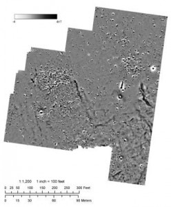
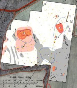
Science comes to the rescue here. Physicists and engineers have developed several methods of peering into the ground to find out what is there, of which the most basic is the old-fashioned metal detector. Surface-penetrating radar is one exciting new method, which has been especially useful for finding cemeteries and graves. At the Dale Site we used another method, high-resolution magnetometry. By measuring minute variations in the earth’s magnetic field, this machine can find many kinds of buried objects, including stone or brick foundations and concentrations of metal like the nails from a wooden building. The raw data that came from our magnetometer study is shown at the top. Below is an interpreted map of the same data. The red regions are places where buildings probably stood, and green dot No. 3 turned out to be a well. Using this data, we were able to zero in on the places where the most interesting discoveries could be made below the surface, saving a lot of time and money.
