
Facebook Twitter Flickr YouTube RSS Feed

Written on: June 12th, 2014 in Route 26
Below is an outline of the anticipated construction schedule and associated lane closures for work on the Route 26 Widening Project during the next two weeks.
Monday June 16, 2014 through Friday June 20, 2014
Continue reconstruction of the Central Avenue/Route 26 intersection. Motorists should anticipate eastbound or westbound lane closures on Route 26 between West Avenue and Woodland Avenue with traffic alternating through the work zone utilizing a flagging operation between 07:00 p.m. and 6:00 a.m. as well as lane closures on Central Avenue at Route 26 with traffic alternating through the intersection utilizing a flagging operation by law enforcement and construction personnel between 07:00 p.m. and 6:00 a.m.
Continue reconstruction of the Old Mill Road/Route 26 intersection. Motorists should anticipate lane closures at Old Mill Road and Route 26 with traffic alternating through the intersection utilizing a flagging operation by law enforcement and construction personnel between 07:00 p.m. and 6:00 a.m.
Continue work on the installation of the new drainage system between Cedar Drive and Old School Lane. Motorists should anticipate the eastbound or westbound lane of Route 26 between Old Mill Road and Old School Lane to be closed with traffic alternating through the work zone utilizing a flagging operation between 07:00 p.m. and 6:00 a.m.
Continue excavation of Storm Water Management Pond #332 located east of Route 17 (Roxana Road) during the day. No lane closures are anticipated for this work.
Continue excavation of Storm Water Management Pond #331 located west of Irons Lane. No lane closures are anticipated for this work.
Monday June 23, 2014 through Friday June 27, 2014
Continue reconstruction of the Old Mill Road/Route 26 intersection. Motorists should anticipate lane closures at Old Mill Road and Route 26 with traffic alternating through the intersection utilizing a flagging operation by law enforcement and construction personnel between 07:00 p.m. and 6:00 a.m.
Continue work on the installation of the new drainage system between Grants Avenue and Woodland Avenue. Motorists should anticipate the eastbound or westbound lane of Route 26 between Old Mill Road and Woodland Avenue to be closed with traffic alternating through the work zone utilizing a flagging operation between 07:00 p.m. and 6:00 a.m.
Continue excavation of Storm Water Management Pond #332 located east of Route17 (Roxana Road) during the day. No lane closures are anticipated for this work.
Continue excavation of Storm Water Management Pond #331 located west of Irons Lane. No lane closures are anticipated for this work.
Written on: June 5th, 2014 in Route 26
Monday June 9, 2014 through Friday June 13, 2014
Begin reconstruction of the Central Avenue/SR 26 intersection. Motorists should anticipate eastbound or westbound lane closures on SR 26 between West Avenue and Woodland Ave with traffic alternating through the work zone utilizing a flagging operation between 07:00PM and 6:00AM as well as lane closures on Central Avenue at SR 26 with traffic alternating through the intersection utilizing a flagging operation by law enforcement and construction personnel between 07:00PM and 6:00AM.
Continue reconstruction of the Old Mill Road/SR 26 intersection. Motorists should anticipate lane closures on Old Mill Road at SR 26 with traffic alternating through the intersection utilizing a flagging operation by law enforcement and construction personnel between 07:00PM and 6:00AM.
Continue work on the installation of the new drainage system between Old Mill Road and Old School Lane. Motorists should anticipate the eastbound or westbound lane of SR 26 between Old Mill Road and Old School Lane to be closed with traffic alternating through the work zone utilizing a flagging operation between 07:00PM and 6:00AM.
Monday June 16, 2014 through Friday June 20, 2014
Continue reconstruction of the Central Avenue/ SR 26 intersection. Motorists should anticipate eastbound or westbound lane closures on SR 26 between West Avenue and Woodland Ave with traffic alternating through the work zone utilizing a flagging operation between 07:00PM and 6:00AM as well as lane closures on Central Avenue at SR 26 with traffic alternating through the intersection utilizing a flagging operation by law enforcement and construction personnel between 07:00PM and 6:00AM.
Continue reconstruction of the Old Mill Road/SR 26 intersection. Motorists should anticipate lane closures on Old Mill Road at SR 26 with traffic alternating through the intersection utilizing a flagging operation by law enforcement and construction personnel between 07:00PM and 6:00AM.
Continue work on the installation of the new drainage system between Grants Avenue and Woodland Avenue. Motorists should anticipate the eastbound or westbound lane of SR 26 between Old Mill Road and Woodland Avenue to be closed with traffic alternating through the work zone utilizing a flagging operation between 07:00PM and 6:00AM.
Continue excavation of Storm Water Management Pond #332 located east of SR 17 (Roxana Road). No lane closures are anticipated for this work.
Written on: May 22nd, 2014 in Route 26
Tuesday May 27, 2014 through Friday May 30, 2014
Continue work on the installation of the new drainage system between Old Mill Road and Grants Avenue. Motorists should expect the eastbound or westbound lane of SR 26 to be closed between Old Mill Road and Grants Avenue with traffic alternating utilizing a flagging operation between 07:00PM and 6:00AM.
Begin reconstruction of the Old Mill Road/SR 26 intersection. Motorists should expect lane closures on Old Mill Road at SR 26 with traffic alternating through the intersection utilizing a flagging operation by law enforcement and construction personnel between 07:00PM and 6:00AM.
Begin work on installation of new Sussex County Sewer line between the Millville Town Limits and Powell Farm Road. Motorists should expect the eastbound or westbound lane of SR 26 to be closed between SR 17 (Roxana Road) and Whites Neck Road with traffic alternating utilizing a flagging operation between 07:00PM and 6:00AM.
Continue excavation of Storm Water Management Pond #332 located east of SR 17 (Roxana Road). No lane closures are anticipated for this work.
Monday June 2, 2014 through Friday June 6, 2014
Continue work on the installation of new drainage system between Old Mill Road and Grants Avenue. Motorists should expect the eastbound or westbound lane of SR 26 between Old Mill Road and Grants Avenue to be closed with traffic alternating utilizing a flagging operation between 07:00PM and 6:00AM.
Continue reconstruction of the Old Mill Road/SR 26 intersection. Motorists should expect lane closures on Old Mill Road at SR 26 with traffic alternating through the intersection utilizing a flagging operation by law enforcement and construction personnel between 07:00PM and 6:00AM.
Continue installation of the new Sussex County Sewer Line between the Millville Town Limits and Powell Farm Road. Motorists should expect the eastbound or westbound lane of SR 26 to be closed in the area of SR 17 (Roxana Road) with traffic alternating utilizing a flagging operation between 07:00PM and 6:00AM.
Continue excavation of Storm Water Management Pond #332 located east of SR 17 (Roxana Road). No lane closures are anticipated for this work.

Written on: May 22nd, 2014 in General
The meeting was called to order at 10:05AM by Ken Cimino of AECOM. Ken welcomed everyone in attendance and thanked them for their participation in the meeting and for their commitment to their community. Ken then asked each of the members of the SR 26 Project Team to introduce their selves.
The first order of business was to ask if the group had reviewed the minutes from meeting #1 and had any questions or comments.
The meeting moved forward with Len Brooks and Mike Delp from George & Lynch, Inc. giving a brief project status update. Len advised that force main location #1, which was in the intersection of SR 26 and Central Avenue, was completed. Len then advised that work had commenced on force main location #8 and force main location #9, which are located between Town Road and the Assawoman Canal. Len also advised that construction of the new Storm Water Management Pond #331, located west of Irons Lane in Clarksville, had also commenced.
The next topic of discussion concerned a Tidewater Utility, Inc. contract that was recently awarded to George & Lynch. Len indicated that work had commenced on the installation of approximately 10,000 feet of new water main that extended from the limits of the Town of Ocean View to just east of SR 17 (Roxana Road). Ken advised the group that this new water main project was separate from DelDOT’s SR 26 Mainline Project and that any questions or concerns should be addressed to Tidewater Utilities, Inc. The Tidewater Utility, Inc. representative for this project is Mr. Greg Coury, Project Engineer. Mr. Coury can be reached at (302) 734-7500 or by email at gcoury@tuiwater.com.
Ken gave an update on the completion of the force main relocation work at SR 26 and Central Ave. Central Avenue was closed at SR 26 on Tuesday, April 1, 2014 and reopened to traffic on Thursday, April 23, 2014 after 22 days of construction. This was well ahead of the anticipated construction duration of four (4) to six (6) weeks.
Ken next addressed some of the concerns that the project team received concerning the closure of Central Avenue at SR 26. Specifically, many residents believed that DelDOT detoured traffic through the local community. Ken explained that DelDOT’s posted detour route directed motorists along DelDOT owned and maintained roadways and did not encourage motorists to “cut through” the local communities to reach SR 26.
Len next discussed future planned construction activities that George & Lynch would be working on. Specifically, Len indicated that Georg & Lynch would be focusing on upgrading intersections along SR 26. These intersections are located at SR 26 and Old Mill Road and SR 26 and Cedar Avenue.
Ken gave a brief overview of what residents can expect in the form of lane closures from May 15th through September 30th.
The presentation portion of the meeting wrapped up with Ken giving a brief update on the Project Team’s Community Outreach efforts. Ken mentioned that the Project Team had a Spring Planning meeting with the Emergency Services Working Group on Thursday, April 24, 2014 at the Millville VFD 84 Fire Station. The meeting was to review how coordination between the Emergency Responders has been when the contractor has had lane closures. To date, there have been no significant issues or concerns. The Emergency Services Working Group has developed a Standard Operating Procedure (SOP) for moving Emergency Response Vehicles through the work zone during lane closures. The group will be meeting again on June 5, 2014 to review operations after the Memorial Day Holiday.
The floor was then opened to questions, comments and concerns from those in attendance.
Q. I was told at a meeting this morning that the entrance to a particular business was going to be closed for up to two weeks when road construction was occurring in front of this business?
A. Ken assured the attendee that business and residential entrances would remain open during construction activities.
The meeting was adjourned at 10:25AM. DelDOT’s Public Relations staff will send out a notice for the next meeting of the SR 26 Construction Advisory Group.
Written on: May 22nd, 2014 in Route 26
Meeting was called to order at 10:05 am by Jill Frey of Century Engineering who noted that this was the first official Construction Advisory Group meeting (meetings have been called Working Group meetings up until now and were limited to select participants, whereas the meetings now are open to the general public). The purpose of the meeting is to communicate information to the public regarding the SR 26 Mainline Project. She encouraged all attendees to add their names to the sign in sheets, and leave an email or a mailing address so they can get timely updates on the project.
Next, Jill introduced the construction team consisting of Brad Saborio, Group Engineer for DelDOT; Ken Cimino, Tim Ratajack and Sam Bostick of AECOM, who represent the consultant inspection team and Chris Baker from George and Lynch. She indicated that Ken is the lead public outreach staff person on the project.
Jill provided a quick review of the project details, including the purpose of adding a center turn lane and widening the two existing lanes for the remainder of SR 26 from Assawoman Canal to the church in Clarksville. This is much like the widening project that was done in 2001 from SR 1 to the Assawoman Canal. Jill indicated that we will conduct monthly meetings (or as needed) as the project continues. She indicated the project was advertised in the summer of 2013 and awarded to George and Lynch in fall of 2013.
As for the status of work, Jill indicated that we are working to finish advance utility relocation work, sewer relocation, clearing and grubbing. She further noted that we had our first major closure last week with the closure of Central Avenue at SR 26. At this point in the meeting, she turned it over to Chris of George and Lynch for a comprehensive project status update.
Chris indicated that to date they have been clearing and grubbing and working with the utility companies to have them complete their work. He indicated that any trees that needed to be removed, have been taken down and they are in the process of removing some stumps. They are also working at the pump station on the west end and moving material. They also did some temporary paving at Central Avenue and SR 26 in advance of the closure so that two lanes of traffic could be maintained.
This spring they will be focused on two sanitary sewer force mains and will then move east. This work will be done by May 15, per the contract requirements. They will do storm drain work, then road widening near Food Lion working their way east. They will then work on the gravity sewer work around the Hocker’s Grocery Store area once utility work is done at that location.
After May 15, night work will begin, as the contract states they cannot close lanes during the day, and that two lanes of traffic must be maintained at all times. They are permitted to work at night and/or they can work off of the roadway after May 15.
At this point Ken introduced himself and indicated that on April 1st, Central Avenue was closed between Fred Hudson/SR 26 and Cedar Drive/SR26. We plan to have it opened in about ten days, following sewer work at that location. Currently, DelDOT, Century Engineering, AECOM, and George & Lynch are working on an alternate design which will allow the project to progress much quicker than the originally anticipated four to six week timeframe. Ken further noted that he has been doing an extensive amount of public outreach with businesses and residences. Ken emphasized that public feedback is very important, and he encouraged everyone to make contact with him if needed.
That concluded the update and a question/answer period commenced.
Q: Woodland Avenue is a road that is being used by local traffic, and it has developed many potholes. Would it be possible to get them repaired?
A: Ken indicated that he has been in discussions with the Town of Ocean View, and that they are working to address this issue.
Q: Will the sewer work in Ocean View effect those living in Bethany?
A: No.
Q: In Bethany, past the Assawoman Canal, will the two lane road be increased to three lanes, and when?
A: Yes, in the area of the Assawoman Canal, for the portion in Bethany, is scheduled to be increased from two lanes to three lanes (center turn lane) in late 2015. While exact dates are not nailed down yet, we will be able to provide a more specific date as the work progresses.
Q: What is the final completion date for the project?
A: The final completion date for the project is June 24, 2016, weather dependent.
Comment: Gentleman noted he was impressed with the way this project is getting done. He praised the project team and legislators for being persistent about the project. The involvement is astounding. All have been very open and transparent.
Response: Jill noted that our goal is to communicate the project to the public. We would rather hear about complaints up front so that we can address them. Ken indicated he lives locally, so he is accessible seven days a week if needed.
Comment: Debbie Botchie indicated that the Town of Millville has found Ken and the contractor to be very accommodating.
Q: Will the force main relocations have an impact on SR 26 traffic?
A: Mike Delp with George and Lynch indicated that at Location 8 (along SR26 westbound shoulder in front of CSI Granite & Marble) they will be working in the shoulder of the road, and at Location 9 (entrance to CSI Granite and Marble) they are working up the driveway of the Granite Store, so there should not be any significant lane closures. There may be temporary moving of equipment, but no lane closures.
Q: Regarding the public safety of nearby, alternate roads, where three deaths have occurred, specifically Burbage Road, Route 17, Powell Farm Road, is there any plan to lower the speed limit or place traffic circles (as was previously proposed) on these roads?
A: There are no plans to lower the speed limit, however, because of crash history we do have traffic studies monitoring and doing studies to determine if any changes are warranted (bigger stop signs, rumble strips, etc.). Likewise, through construction, we will monitor these locations. DelDOT is working with Delaware State Police for extra enforcement. Tracy Condon of DSP indicated that based on today’s conversation they will be setting up extra patrols in these areas. As for the traffic circle that was planned for south of Route 17, which would require a drop in speed limit, this is not moving forward. The road is designed per DelDOT standards.
Q: Is this supposed to be a three year, 24/7 project?
A: In designing the project, we didn’t make them do night work, as we have built in, lane closures in the work schedule. When they can’t work days in the summer, they will work nights. George and Lynch makes the final decision on their work schedule, but must abide by the work hours set out in the contract. The goal is to complete the project in three years, as much as within our control (weather dependent).
Comment: The weekly update emails are great.
Q: Have any days been added to the contract for weather yet?
A: No days have been added to the contract yet. We still anticipate to be done by June 24, 2106.
Q: Why are we meeting at the Bethany Beach Town Hall when there are plenty of places to meet along SR 26?
A: The Public Relations team needed to select a location that could be available the same day/time every month, on a date that accommodated the project team’s schedule. Other locations could not accommodate that schedule, but the Bethany Beach Town Hall could, thus we went with them to ensure a consistent time and location.
At this point Ken recognized that Rep. Gray had entered the meeting room, and asked if he wished to make any comments. Rep. Gray asked if we could get the Garfield Parkway project completed quickly, and was pleased that Mediacom was onsite.
At this point Ken indicated that meeting minutes would be sent out which would indicate the next meeting date and time. At this point the meeting was concluded.

Written on: May 2nd, 2014 in Archaeology Updates, US301
Alternative Mitigation of the Polk Tenant Site (7NC-F-111) April, 2014
One of the things archaeologists are interested in is what archaeological sites can tell us about how people organized their space. We took a look at where the wells in our sample were located to see how far they were from the nearest buildings or structures. What we learned is that most wells were very close to at least one structure on site. First we looked at the distance to the principal structure or dwelling recorded on the site. Figure 1 shows the average distance between excavated wells and the site dwelling by material. All of the well types averaged between 30 and 56 feet away. However, there was substantial variation in the distances recorded. The greatest variability was found among wood frame lined wells, which were found as far away as nearly 200 feet from the dwelling.
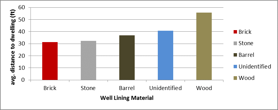
Figure 1: Average distance between excavated wells and principal site building by material
Then we looked at the distance between the wells in our sample and the nearest structure of any kind, which included not only dwellings, but working structures such as smokehouses, dairies, wash houses, and stables. When we did, we found that the average distance and the variability in that distance were both less than with the distance to the main site building. With the exception of wood box lined wells, excavated wells averaged just 20 feet from the nearest structure. Water isn’t just necessary for people and animals to drink, it’s also necessary for many kinds of work. It makes sense that in the days before indoor plumbing, people arranged their homes, farms, and places of work so that needed water was never too far away.
We also took a look at the material used to make wells for outbuildings and compared those to wells nearest to the main structure on site. The percentage of outbuilding wells made with barrels or brick do not seem to differ much from main building wells. However, the percentage of wells that are made of stone or wood framing does differ. It seems that barrel and brick wells were no more or less likely to be associated with an outbuilding than with the principal structure on site, but that stone wells were more likely to be associated with a dwelling or other principal structure and wood-lined wells were more likely to be associated with an outbuilding. This is unsurprising given the relative effort to build a stone-lined versus a wood frame well that stone-lined wells would be reserved for the most important structures on a site. They might also be expected to last longer, and need repair less frequently.
Written on: March 25th, 2014 in Archaeology Updates, US301
Update for the Levels Road-Rumsey Polk Site
Who’s Afraid of the Big Bad Wolf?
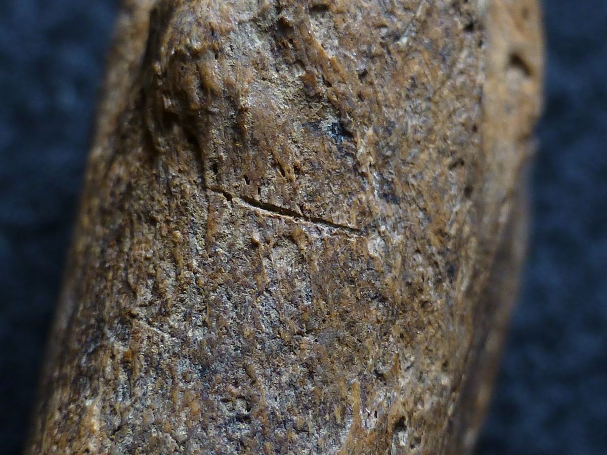
Eighteenth-century occupants of the Rumsey/Polk Tenant/Prehistoric Site (CRS # N-14492; 7NC-F-112) in St. George’s Hundred near Middletown may not have been at the top of the food chain. They struggled to protect themselves with hunting, trapping, and laws providing bounties for killing wolves. Predation by wolves was not just part of a bad fairy tale. It was a real and frightening part of their lives threatening both livestock and people. Artifact and faunal analysis are underway for the Phase II/III archaeological investigations at the Rumsey/Polk site and are revealing some fascinating tidbits about the lives of the site’s residents. RGA’s staff faunal expert, Dr. Adam Heinrich, has identified the bones of a wolf from Feature 5, a subfloor pit that also yielded fragments of an iron kettle, large pieces of a North Devon gravel tempered crock or jar, portions of a riding saddle, and many fragments of an imported English hand painted creamware canister-shaped teapot. The range of artifacts and faunal remains hints at some of the day-to-day tensions and challenges faced by these folks, tenants of the socially prominent Rumsey family. The wolf bones include the right and left scapulae (shoulder blades), the right ulna and radius (forearm bones), and most of the right front foot. Even more intriguing, the bones were butchered. The wrist end of the radius and ulna contain cut marks made by a metal knife. The location of these marks near the animal’s wrist indicates removal of the wolf’s pelt after it was killed. The wolf found in Feature 5 may have been shot. An oval shaped pit with crushed bone within it is located on the animal’s elbow, consistent with being shot with the lead balls from a musket or comparable firearm. It is uncertain if being shot in the elbow had killed the wolf, but it may have injured it enough to be finished off more easily. Ongoing analysis is expected to reveal more about the site’s occupants and their lives in this world that was still part of the frontier in eighteenth century Delaware.
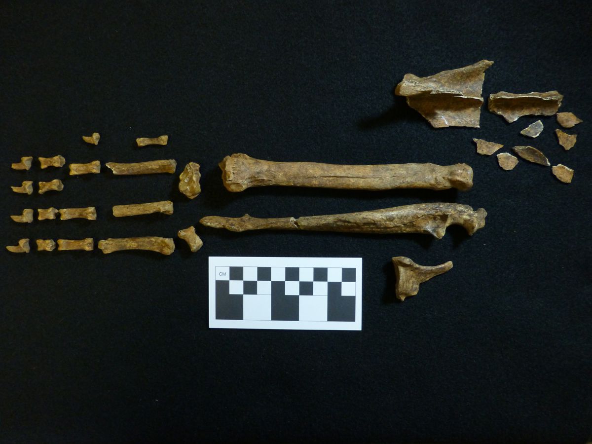
Wolf bones from Feature 5
Written on: March 25th, 2014 in Archaeology Updates, US301
Cardon-Holton Site 7NC-F-128 (Hunter Research, Inc.)
Analysis is underway on the data from the Cardon-Holton site 7NC-F-128. Hunter Research, Inc. is currently working with a range of specialists to explore different types of material recovered in the excavations.
The most exciting information to date comes from the preliminary examination of the wood recovered from the well feature at the Cardon-Holton site 7NC-F-128 by the Oxford Tree-Ring Laboratory. This has provided us with two dates: 1737 and 1753. The on-going study of historic wells in Delaware indicates that very few firm dates exist, and most are derived from artifact evidence rather than the much more precise information from tree rings. Conservation of the wood from the well is underway at the Maryland Archaeological Conservation Lab, providing a preserved example of dated well-timbering from Delaware.
Our assumption is that the two dates reflect the initial construction and a subsequent repair/replacement of structural members of the well casing. Archaeological evidence suggested the well had been either deepened or repaired, as the upper portion exhibited signs of shoring atypical of normal well construction. Deepening of the well may have been in response to a drought. Repairs are common for wooden wells given their perishable nature in an environment with a fluctuating water table.
The two dates can be compared with the site occupation range of 1720 to 1740 suggested by the ceramic assemblage. As the site was situated adjacent to an intermittent stream and a likely spring head, there may not have been a need for a well initially… until perhaps a drought caused their water source to dry up. Was the well constructed in response to a drought which caused the spring head to run dry during the occupation? Initial research shows that a severe drought hit the region in 1730. Could the well have been maintained or re-established for agricultural use after the domestic occupation had ceased to exist at the site by the new owners of the property who established a residence immediately to the north at the Holton-Cann site?
Just as interesting is the initial examination of the faunal materials by Adam Heinrich, who has identified not only the remains of a very old horse and cow, but also coyote and bear teeth!
Other specialists are analyzing soil samples for chemical signatures, macro-floral remains, phytoliths and pollen remains. These studies will help to piece together a picture of the former environment at the site.
Written on: March 10th, 2014 in Archaeology Updates, US301
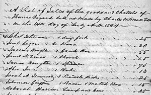
In the course of researching African American life in St. Georges Hundred for the Dale site alternative mitigation, the Louise Berger Group came across the probate records of Thomas Bayard, who died in 1864. Bayard was a farmer who lived just east of Odessa, Delaware, a prosperous man who owned a dozen horses, an “old pleasure carriage,” six silver tea spoons, and a French silver watch. He was one of the two richest African Americans in his part of Delaware, probably one of the ten richest in the whole state. When he died, he left a will calling for his whole estate to be sold, including the land, and the money divided among his heirs. Probably this was his children’s own wish — probably they wanted to move to the city or study for the ministry, so the farm was sold to further their ambitions. This made his estate sale a big event. The whole contents of a prosperous, up-to-date farm were auctioned off, from the cows to the bed sheets, and the whole neighborhood turned out to bid. The record of the sale lists 193 lots sold to 36 different bidders, with a total value of $400.
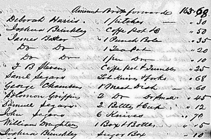
Perhaps the most interesting thing about the sale is that the bidders were about equally black and white. Fifteen African-Americans brought something home from the sale, along with 21 whites. Six of the bidders were women, one white and five African American. The document shows no sign of segregation, as black and white names are mixed together in haphazard order. They bought some of the same things, too. The women bid mainly on household items, although one bought a beehive, but the black and white men bid on everything. A wealthy white man bought some of Bayard’s bed sheets and pillow cases. In the small section above (the sale spills across six pages), Harris, Brinckley, Segars and Griffin are African American families, but Stevens, Chambers, and Doughten were whites. Surely this was one of the most thoroughly integrated events in the history of Delaware up to that time.
What could bring blacks and whites together in America? A bargain.
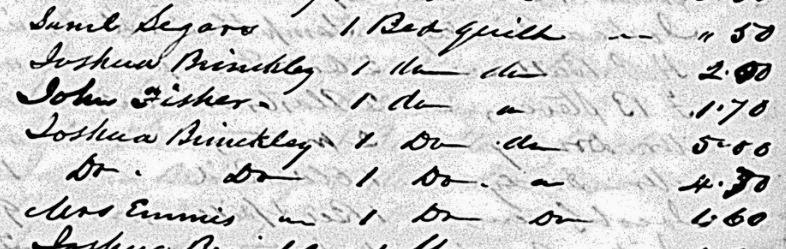
Two of the quilts in the section above are also intriguing. Quilts typically sold for a dollar or two, but two of Thomas Bayard’s quilts sold for $5.00 and $4.70. Those must have been very fine quilts indeed to have brought that price from these practical farm folk. Some woman in Thomas Bayard’s household must have been an ace quilt maker. The valuable quilts were bought by Joshua Brinckley, who was married to Bayard’s daughter Eliza, so perhaps he and his wife were determined to keep grandma’s best work in the family.
Written on: March 4th, 2014 in Archaeology Updates, US301
Alternative Mitigation of the Polk Tenant Site (7NC-F-111), February, 2014
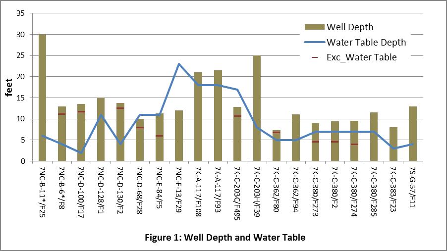
This month we’re continuing in our analysis of well data in Delaware, taking a look at well depth and the local water table. Perhaps one of the most salient characteristics of the wells in our sample is that many of them are very shallow. None of those for which bottom depth was recorded is deeper than 30 feet, and all but 4 of those are 15 feet deep or less. Three other wells were excavated to below 20 feet, but the depth at the bottom was not documented for these. Figure 1 illustrates the data for the 20 wells for which the bottom depth was identified. The depth recorded by the archaeology is shown (the height of the bar) along with a blue line that shows the average depth of the water table according to the Natural Resources Conservation Service, a division of the USDA that collects data about soils and water. The red line on some of the bars indicates the depth at which archaeologists recorded the water table. Most of the excavated wells show a close agreement between the predicted or observed water table and the depth of the well.
This has obvious implications for the technology used to dig and line these wells, and also for the potential reliability and quality of the water obtained. With the exception of the wells at 7NC-B-11 (Weldin Plantation) and 7K-C-203 (John Powell Plantation), the wells in the sample were dug little deeper than the water table. One advantage of shallow wells is that they don’t require any special technology to dig, and you can get away with fairly expedient technologies for linings, like using barrels. On the other hand, such materials might be more prone to fail than masonry linings, requiring that site occupants dig new wells periodically. In fact, 12 of the sites in the sample include multiple wells that may have been used in succession, including the Moore Taylor Farm (7K-C-380) which had five wells. Shallow wells might also be prone to contamination.
One significant problem with this data set is that the original constructed depth of the well was only recorded for 20 of the 53 features documented. Not fully excavating a deep well is understandable, given the challenges and hazards associated with excavation below the water table. However, not documenting the base of the well poses an obvious dilemma for interpreting well technology in Delaware. Answering the question about whether people in Delaware sometimes dug their wells deeper to avoid them running dry requires that the bottom depth be determined and clearly documented. Finding the base of the well may also be important for dating, since material deposited at the bottom of a well may indicate the period of use and abandonment. Material recovered near the top of a well, in contrast, may be related to much later activity, perhaps when the site as a whole was abandoned.
Delaware's Governor
State Agencies
Elected Officials
General Assembly
Delaware Courts
State Employees
Cities & Towns
Delaware State Code
State Regulations
Business First Steps
Phone Directory
Locations Directory
Public Meetings
Voting & Elections
Transparency
Delaware Marketplace
Tax Center
Personal Income Tax
Privacy Policy
Weather & Travel
Contact Us
Corporations
Franchise Tax
Gross Receipts Tax
Withholding Tax
Delaware Topics
Help Center
Mobile Apps
E-mail / Text Alerts
Social Media

Built by the Government Information Center
©MMXVIII Delaware.gov

