
Facebook Twitter Flickr YouTube RSS Feed

Written on: May 14th, 2013 in Archaeology Updates, US301
Phase III fieldwork at the Warwick Site ended on May 9th, with the completion of 33 test units. Fifty-nine square meters, or roughly 635 square feet, were excavated during the Phase I through III fieldwork. All artifacts have been returned to the lab for cleaning and detailed analysis. The artifacts will be measured, weighed, and classified by type of stone, reduction stage, and shape. Reduction stage refers to extent to which tools have been shaped and thinned, and to the point in tool manufacturing when flakes were removed. For example, during the initial stage, as the tool is roughly shaped, flakes tend to be large and the weathered exterior of the stone, termed the cortex, is often present. In contrast, sharpening a finished tool tends to produce small flakes that lack cortex on the flake. In addition, points will be classified by reference to standard sources, like William Ritchie’s A Typology and Nomenclature for New York Projectile Points and Noel Justice’s Stone Age Spear and Arrow Points of the Midcontinental and Eastern United States; on-line information posted by Delaware’s Historic Preservation Office (http://history.delaware.gov/archaeology/points/start.shtml) and Maryland’s Jefferson Patterson Park and Museum will also be consulted (http://www.jefpat.org/diagnostic/Maryland_Projectile_Points/index-projectilepoints.html). The information will then be typed into a data base for analysis.
Written on: May 14th, 2013 in Archaeology Updates, US301
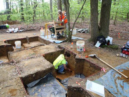
The previous post characterized the Warwick Site as a way station where small groups monitored game trails, sharpened tools, and consumed packed snacks, locally available foods, or both; ongoing excavation of the Warwick Site has reinforced this assessment. Nevertheless, the more robust view of the spatial distribution of artifacts across the site revealed by newly excavated test units highlights variation in the density and location of different types of artifacts and, perhaps, different activities, and has implications for the length and type of past occupations. Within the core of the site, for example, artifact density reached 30 to 65 artifacts per test unit, well above the amount recovered from most test units. In contrast, very few artifacts occurred in the southeastern test units, though several tools were unearthed in that area and a small basin-shaped pit was identified during the earlier work. The pit contained only charcoal and very small fragments of chipping debris that would have fallen through the screens used to standardize artifact collection. Microdebitage, the archaeological term for the very small chips recovered by passing the sediments from the feature through screens similar to mosquito mesh, may be one key to evaluating the way-station hypothesis.
Two ethnographic observations illustrate the value of microdebitage: 1) people maintain sleeping and common areas by relocating large debris to the unused portions of the landform; and 2) the extent of maintenance and the organization of space tend to correlate with length of stay at a location. While cleaning, people often overlook extremely small fragments of chipping debris. If, therefore, flintknappers sharpening tools created the artifact-rich core of the site, microdebitage should be present. The absence of very small debris implies that larger material was tossed or swept from the actual location where tools were manufactured. Similarly, if a dearth of microdebitage does not accompany the dearth of refuse in the southeastern corner of the excavation block, the proposed interpretation flounders. The presence of significant amounts of microdebitage in an artifact-poor area implies extensive cleaning around the pit feature. The level of maintenance and spatial organization implied by extensive cleaning of a living area suggests a longer-term occupation that required more extensive organization of the use of space than predicted by the way-station hypothesis. Consequently, samples collected from the test units will be screened through fine mesh and examined under low magnification to assess the presence and frequency of microdebitage in different portions of the site.
Written on: May 6th, 2013 in Archaeology Updates, US301
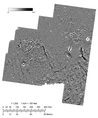
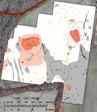
The next task in the ongoing study of the Dale Site is to make write a detailed report on the archaeological findings. Looking back over the work that we did, one of the most interesting items was the geophysical study we made of the site. Archaeologists are always looking for new ways to find out what is under the ground. Hand excavation is slow and expensive, and excavation with a machine is destructive. The problem is especially vexing at the testing level, what we call Phase II. Before we commit money and time to excavating a site, we would like to know if our efforts will be repaid by significant finds below ground, things like building foundations and pits full of artifacts. But how to learn that without either putting weeks into hand digging through plowed soils, or stripping that plowed soil away with a backhoe?
Science comes to the rescue here. Physicists and engineers have developed several methods of peering into the ground to find out what is there, of which the most basic is the old-fashioned metal detector. Surface-penetrating radar is one exciting new method, which has been especially useful for finding cemeteries and graves. At the Dale Site we used another method, high-resolution magnetometry. By measuring minute variations in the earth’s magnetic field, this machine can find many kinds of buried objects, including stone or brick foundations and concentrations of metal like the nails from a wooden building. The raw data that came from our magnetometer study is shown at the top. Below is an interpreted map of the same data. The red regions are places where buildings probably stood, and green dot No. 3 turned out to be a well. Using this data, we were able to zero in on the places where the most interesting discoveries could be made below the surface, saving a lot of time and money.
Written on: May 3rd, 2013 in Archaeology Updates, US301
Watch as Mike Klein, Archaeologist, from Dovetail Cultural Resource Group discusses the excavations at the Warwick Native American Archaeology site for the US RT 301 project.
Written on: May 3rd, 2013 in Archaeology Updates, US301
Watch as Michael Carmody, Archaeologist, from Dovetail Cultural Resource Group gives an update on the excavations at the Warwick Native American Archaeology site.
Written on: May 3rd, 2013 in Archaeology Updates, US301

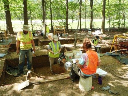
Continuing work at the Warwick Site completed the excavation of roughly half of the open units. Plowing, among other processes, appears to have obliterated any evidence for structures, hearths, or storage pits. For the most part, artifacts occurred in the plow zone and the uppermost portion of the subsoil. Below that depth, artifact density dropped precipitously, with only a few small pieces of sharpening debris from stone tools were recovered per level. Although archaeological sites exhibiting a layer-cake accumulation of living surfaces from different periods of time are known in the northern Delmarva Peninsula, plowing, burrowing, and roots likely explain the artifacts recovered below the uppermost portion of the subsoil at the Warwick Site. .
Various point forms traditionally assigned to the Late Archaic and Early Woodland periods, similar to those recovered during the earlier fieldwork, have been recovered. Yellowish brown jasper appears to predominate, though red jasper, gray chert, quartz, and quartzite have been recovered. Tools include a few bifaces and unifaces, the latter including a few with tools with steep edge angles typical of hide scrapers. Scattered fire-cracked rock has been recovered; the sole potential feature, however, is three fired rock fragments at the interface between the plow zone and subsoil. The generally low artifact density and predominance of small sharpening flakes seems consistent with tool sharpening and limited food preparation by small groups during short-term stays, the sort of behavior described by studies of locations where modern Arctic hunters monitor game trails. Further excavation during the next session of fieldwork, of course, could identify a long-buried deposit of artifacts, the remains of shelters and hearths, or areas where different types of artifacts cluster.
Written on: April 25th, 2013 in Archaeology Updates, US301
Dovetail Cultural Resource Group (Dovetail), a firm that specializes in archaeological and architectural research, began archaeological fieldwork at the Warwick Site on April 17, 2013. The Warwick Site is a small camp, way-station, or short-term work area occupied by Native Americans between approximately 3,000 and 500 B.C., which spans the periods referred to by archaeologists as the Late Archaic (roughly 3,000-1,000 B.C.) and Early Woodland (roughly 1,000-500 B.C.). Richard Grubb and Associates (RGA), also archaeological and architectural specialists, had identified the site and determined that it was important based on the potential contribution to understanding Native American life in the northern Delmarva Peninsula during the Late Archaic and Early Woodland periods. Both RGA and Dovetail work for the Delaware Department of Transportation; the site will be affected by planned improvements to Route 301.
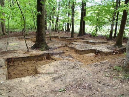
Dovetail began by clearing leaves off the site to identify the location of RGA excavations, and re-establishing the RGA excavation grid. The grid divided the area into blocks of one square meter, or roughly three square feet, thereby controlling for the type and amount of artifacts recovered across the area. Excavation began by expanding the southern portion of the area examined during the earlier work. Soils were pushed through a screen to ensure that all artifacts larger than one-quarter inch are recovered. The root mat and associated organic material and soil and an underlying layer identified as soil plowed 100 or more years ago were removed to expose the less churned-up soils below the plow zone, where the remains of hearths, sub-surface storage pits, and rings of posts that served as the frame for houses or, more likely in this case, temporary huts might occur. Future work will expand the excavation to investigate possible features, as archaeologists refer to the remains of huts and hearths, and remove the unplowed soils that have not been excavated at present.
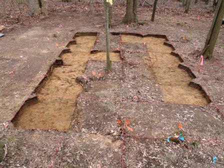 Looking south across the initial excavation blocks after removal of the historic plow zone.
Written on: April 11th, 2013 in Archaeology Updates, US301
We at the Louis Berger Group are very excited to begin work on our alternative mitigation of the Dale Site and the archaeology of African Americans in St. Georges Hundred. The Dale Site, 7NC-F-134, first appeared to archaeologists as so many sites do, as a scatter of artifacts on the surface of a plowed field. Walking the field and picking up potsherds and pieces of glass, using a GPS device to record where each artifact came from, the archaeologists mapped out what looked like three separate house sites in a single small field. The artifacts dated to the 1800s. The site is near Armstrong Corners, a few miles north of Middletown.
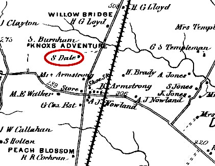
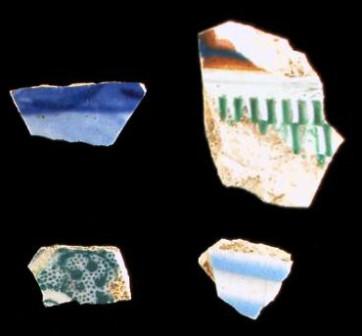
A little research showed that this field was part of a 20-acre property purchased in 1854 by Samuel Dale, an African-American farmer. Dale may have already been residing on the site for some years, since he is listed as a farmer in the neighborhood census for 1850. This Samuel Dale seems to be the same person as Reverend Samuel Dale, minister of Trinity AME Church in Middletown. Samuel Dale died some time before 1882. His property was divided among Samuel Dale, Jr., William Dale, and Temperance Shockley, who were mostly likely his children. This was a striking discovery, since the archaeological site seemed to contain three separate houses; one for each child? Samuel Dale, Jr. died in 1882, and his share of the property was divided between William Dale and Temperance Shockley. This deed was recorded at the county courthouse, unlike most of the others concerning the property, and it is only from this one record that we know about Dale’s death and the division of his farm. In 1915, the Dales sold land to the Armstrong family and moved on. Archaeologists went back to the site in the spring of 2012 to do more testing. They found hundreds of artifacts dating to between 1800 and 1910, divided as before into three separate concentrations. One of the three had many fewer artifacts than the others, but bricks and nails showed that buildings stood in all three spots. No foundations or cellar holes were found, so the buildings probably stood on brick piers. One well was discovered, but it was mostly filled with sterile sand. Because of its connection to the Dale family and the African American history of Armstrong Corners, the Dale Site was considered to be significant. However, the archaeology did not seem very exciting. The artifacts found on the site were all broken into small pieces, and no foundations or artifact-filled pits had turned up. So it was decided to explore the site in a different way, by investigating the history and archaeology of African Americans in St. Georges Hundred. Over the next six months, Berger archaeologists, along with faculty and students from Delaware State University, will be combing through the archives to write a history of African American communities from Middletown to the Canal and assembling all that is known about their archaeology. Because this is an archaeological project, it will focus on the material side of life – houses, farms, food, furniture, dishes, and so on. The goal will be to produce a document called a “historic context,” which will be used to help understand and evaluate any future sites in the region where African Americans lived. It is a fascinating project, and we can’t wait to get started.
Written on: April 10th, 2013 in Archaeology Updates, US301
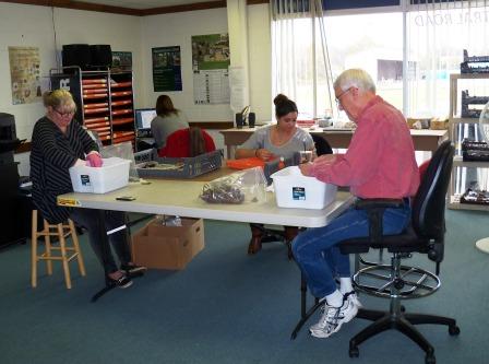
Howdy all, here is another great video from the folks at Dovetail Cultural Resources Group. Take a peek to see Kerry Gonzalez (Laboratory Manager) explain the process artifacts go through in the lab once they come out of the ground from the Houston LeCompt site.
Written on: March 7th, 2013 in Archaeology Updates, US301
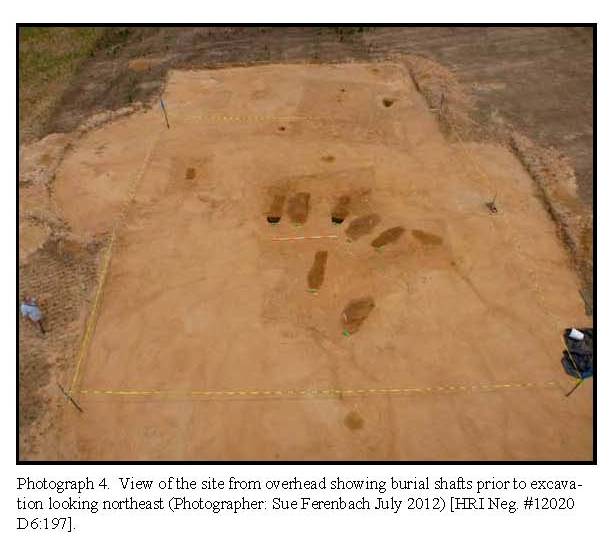
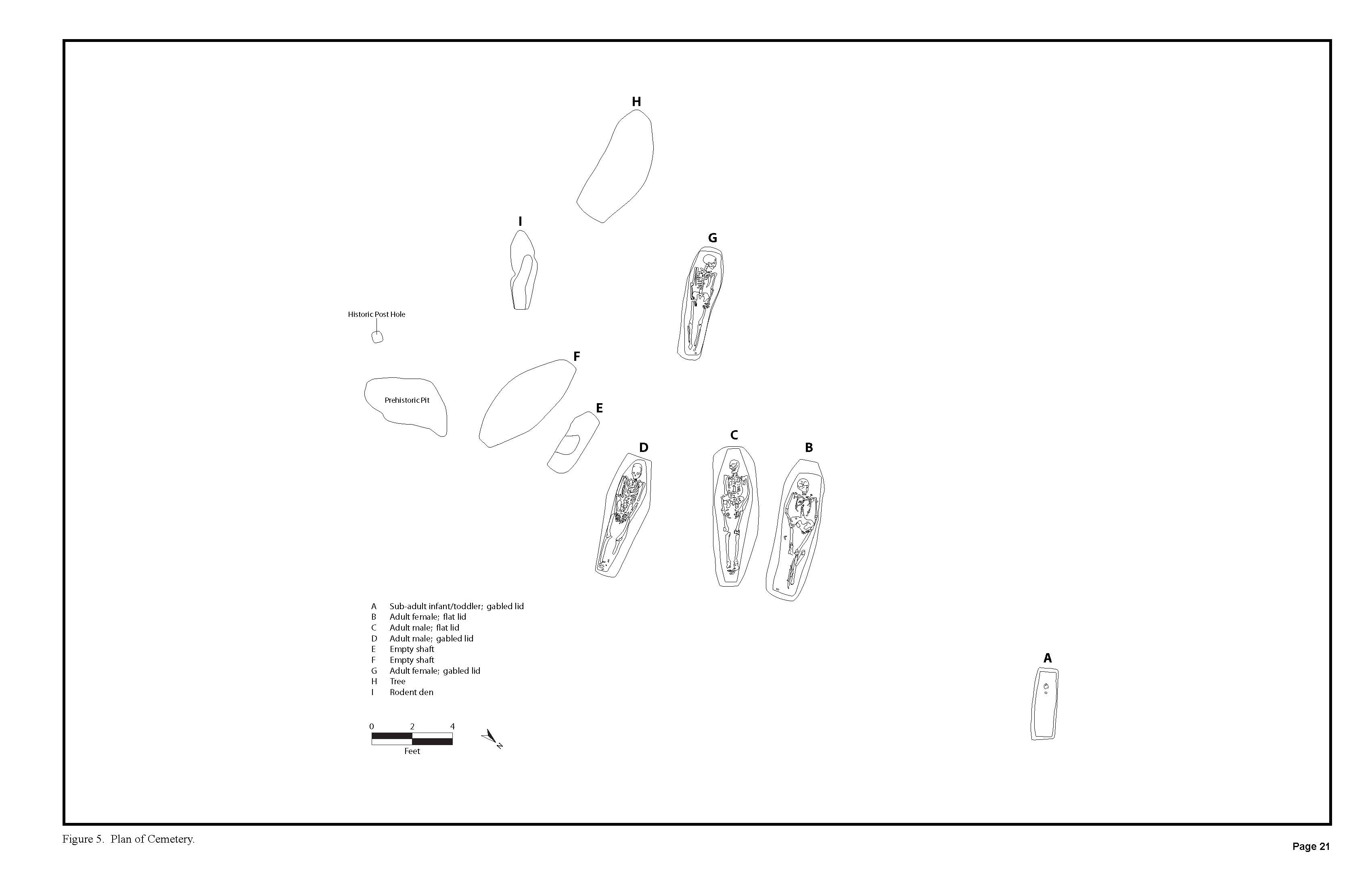
After months of behind the scenes efforts, Hunter Research, Inc. is able to announce the discovery of a small unmarked cemetery at the Elkin site. The State of Delaware has specific laws regulating the discovery of unmarked human remains. A discussion of these laws can be found at the Department of State Division of Historical and Cultural Affairs’ website http://history.delaware.gov. A small distinct hill located northwest of the Elkins A site limits was included for investigations during the Phase II investigations. Excavation Unit 17 identified a feature that was thought at that time to be a large structural post, since no artifacts were recovered from the fill. The Phase II report recommended stripping of the knoll based on the topography and the potential for outbuildings and/or an unmarked cemetery, even though few artifacts had been recovered from the area as a whole.
In the last week of June 2012 Hunter Research removed the plowzone from the small hill to further investigate features discovered during the Phase II investigations. Stripping of the plowzone revealed between six and eight potential grave shaft features facing east-west. These potential grave shafts were assigned letter designations A through H. These suspected unmarked graves were immediately reported to the Director of the Division of Historical and Cultural Affairs of the Department of State, and to representatives from DelDOT. Hunter Research, Inc. was then instructed to test two of the potential grave shafts near the cranial region to establish whether human remains were present. Shafts “B” and “D” were selected for these initial investigations. Human skulls, surviving in good condition, were present in both shafts. These exploratory excavations were backfilled after placing plastic tarps over the remains so that it would be obvious where the remains were when and if excavations resumed. The burial area was then covered with a large plastic tarp and backfilled using a small backhoe.
All efforts were made by DelDOT to avoid the unmarked cemetery but the location, which was directly in the middle of the right-of-way and adjacent to a planned borrow pit, made this impractical. The unmarked cemetery along with a list of potential names was announced in local newspapers so that the next of kin could be notified. No one came forward and a plan for the physical removal of the human remains was developed for DelDOT by Hunter Research, Inc. in close consultation with Dr. Ashley H. McKeown, Associate Professor with the Department of Anthropology at the University of Montana (Missoula), DelDOT, and the DESHPO.
Delaware's Governor
State Agencies
Elected Officials
General Assembly
Delaware Courts
State Employees
Cities & Towns
Delaware State Code
State Regulations
Business First Steps
Phone Directory
Locations Directory
Public Meetings
Voting & Elections
Transparency
Delaware Marketplace
Tax Center
Personal Income Tax
Privacy Policy
Weather & Travel
Contact Us
Corporations
Franchise Tax
Gross Receipts Tax
Withholding Tax
Delaware Topics
Help Center
Mobile Apps
E-mail / Text Alerts
Social Media

Built by the Government Information Center
©MMXVIII Delaware.gov

